
Ben Schumin Photography Portfolio
Ben Schumin is a professional photographer who captures the intricacies of daily life.
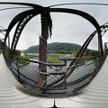
Abandoned bridge piers from a Civil War-era railroad bridge, adjacent to the modern CSX Shenandoah Subdivision bridge. The CSX bridge also contains a footbridge in order for park visitors to walk between Harpers Ferry and Maryland Heights.
![Winchester and Potomac Railroad Bridge [01]](../../../../../i/upload/2024/07/17/20240717230005-0dbdd68e-sq.jpg)
![Winchester and Potomac Railroad Bridge [02]](../../../../../i/upload/2024/07/17/20240717230009-a3433d63-sq.jpg)
![Winchester and Potomac Railroad Bridge [03]](../../../../../i/upload/2024/07/17/20240717230012-c7d0b2e5-sq.jpg)
![Hilltop House, viewed from Maryland Heights [01]](../../../../../i/upload/2024/07/17/20240717230016-2313c799-sq.jpg)
![Hilltop House, viewed from Maryland Heights [02]](../../../../../i/upload/2024/07/17/20240717230019-8dca72a0-sq.jpg)
![Hilltop House, viewed from Maryland Heights [03]](../../../../../i/upload/2024/07/17/20240717230021-aa5ddbf5-sq.jpg)

![View from Maryland Heights overlook [01]](../../../../../i/upload/2024/07/17/20240717230027-95d5dd7e-sq.jpg)
![View from Maryland Heights overlook [02]](../../../../../i/upload/2024/07/17/20240717230031-13ba50bd-sq.jpg)
![View from Maryland Heights overlook [03]](../../../../../i/upload/2024/07/17/20240717230034-cb05c6dd-sq.jpg)

![View from Maryland Heights overlook [04]](../../../../../i/upload/2024/07/17/20240717230040-07c3333d-sq.jpg)
![View from Maryland Heights overlook [05]](../../../../../i/upload/2024/07/17/20240717230043-fe4fd24d-sq.jpg)


![Abandoned house [01]](../../../../../i/upload/2024/07/17/20240717230055-c63c5bfc-sq.jpg)
![Abandoned house [02]](../../../../../i/upload/2024/07/17/20240717230058-5d1cb340-sq.jpg)
![Winchester and Potomac Railroad Bridge [04]](../../../../../i/upload/2024/07/17/20240717230101-0e89deb5-sq.jpg)
Information
Powered by Piwigo