-
Downtown Charlottesville from Market Street garage [01]
![Downtown Charlottesville from Market Street garage [01] (1332 visits) Downtown Charlottesville as viewed from the roof of the Market Street parking garage.
Ben Schumin i... Downtown Charlottesville from Market Street garage [01]](../../i/upload/2024/07/19/20240719115507-cfb820d4-cu_s9999x250.jpg)
-
Interstate 68 through Sideling Hill [08]
![Interstate 68 through Sideling Hill [08] (1345 visits) Interstate 68 as it passes through a cut in Sideling Hill in Washington County, Maryland.
More at T... Interstate 68 through Sideling Hill [08]](../../i/upload/2024/07/19/20240719185626-b8442ab1-cu_s9999x250.jpg)
-
Myersville, Maryland and vicinity [02]
![Myersville, Maryland and vicinity [02] (1407 visits) Myersville, Maryland and the immediate surrounding area, viewed from above the Myersville Volunteer ... Myersville, Maryland and vicinity [02]](../../i/upload/2024/07/19/20240719114533-7da9ff27-cu_s9999x250.jpg)
-
Coin-operated viewer at Sideling Hill cut [02]
![Coin-operated viewer at Sideling Hill cut [02] (1523 visits) A coin-operated viewer at the overlook for the Sideling Hill cut, carrying Interstate 68 through Sid... Coin-operated viewer at Sideling Hill cut [02]](../../i/upload/2024/07/19/20240719185629-71caeafd-cu_s9999x250.jpg)
-
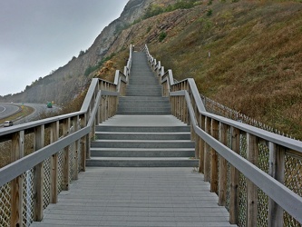
Stairs to Sideling Hill overlook
-
Myersville, Maryland and vicinity [01]
![Myersville, Maryland and vicinity [01] (1536 visits) Myersville, Maryland and the immediate surrounding area, viewed from above the Myersville Volunteer ... Myersville, Maryland and vicinity [01]](../../i/upload/2024/07/19/20240719114529-b09266dc-cu_s9999x250.jpg)
-
Smithsburg, Maryland and vicinity [01]
![Smithsburg, Maryland and vicinity [01] (1560 visits) Aerial view of Smithsburg, Maryland and vicinity.
Ben Schumin is a professional photographer who ca... Smithsburg, Maryland and vicinity [01]](../../i/upload/2024/07/19/20240719114610-c1a5ac24-cu_s9999x250.jpg)
-
Coin-operated viewer at Sideling Hill cut [01]
![Coin-operated viewer at Sideling Hill cut [01] (1582 visits) A coin-operated viewer at the overlook for the Sideling Hill cut, carrying Interstate 68 through Sid... Coin-operated viewer at Sideling Hill cut [01]](../../i/upload/2024/07/19/20240719185632-77ed3978-cu_s9999x250.jpg)
-
Smithsburg, Maryland and vicinity [02]
![Smithsburg, Maryland and vicinity [02] (1610 visits) Aerial view of Smithsburg, Maryland and vicinity.
Ben Schumin is a professional photographer who ca... Smithsburg, Maryland and vicinity [02]](../../i/upload/2024/07/19/20240719114614-27b7e477-cu_s9999x250.jpg)
-
Interstate 68 through Sideling Hill [07]
![Interstate 68 through Sideling Hill [07] (1749 visits) Interstate 68 as it passes through a cut in Sideling Hill in Washington County, Maryland.
More at T... Interstate 68 through Sideling Hill [07]](../../i/upload/2024/07/19/20240719185636-d7e51d92-cu_s9999x250.jpg)
-
Interstate 68 through Sideling Hill [06]
![Interstate 68 through Sideling Hill [06] (1749 visits) Interstate 68 as it passes through a cut in Sideling Hill in Washington County, Maryland.
More at T... Interstate 68 through Sideling Hill [06]](../../i/upload/2024/07/19/20240719185642-d31a5f32-cu_s9999x250.jpg)
-
Interstate 68 through Sideling Hill [11]
![Interstate 68 through Sideling Hill [11] (1783 visits) Interstate 68 as it passes through a cut in Sideling Hill in Washington County, Maryland.
More at T... Interstate 68 through Sideling Hill [11]](../../i/upload/2024/07/19/20240719185554-18184114-cu_s9999x250.jpg)
-
Interstate 68 through Sideling Hill [10]
![Interstate 68 through Sideling Hill [10] (1804 visits) Interstate 68 as it passes through a cut in Sideling Hill in Washington County, Maryland.
More at T... Interstate 68 through Sideling Hill [10]](../../i/upload/2024/07/19/20240719185557-640c945f-cu_s9999x250.jpg)
-
Interstate 68 through Sideling Hill [05]
![Interstate 68 through Sideling Hill [05] (1805 visits) Interstate 68 as it passes through a cut in Sideling Hill in Washington County, Maryland.
More at T... Interstate 68 through Sideling Hill [05]](../../i/upload/2024/07/19/20240719185645-66143f4e-cu_s9999x250.jpg)
-
Interstate 68 through Sideling Hill [01]
![Interstate 68 through Sideling Hill [01] (1805 visits) Interstate 68 as it passes through a cut in Sideling Hill in Washington County, Maryland.
More at T... Interstate 68 through Sideling Hill [01]](../../i/upload/2024/07/19/20240719185659-39bfbedd-cu_s9999x250.jpg)
-
Interstate 68 through Sideling Hill [04]
![Interstate 68 through Sideling Hill [04] (1817 visits) Interstate 68 as it passes through a cut in Sideling Hill in Washington County, Maryland.
More at T... Interstate 68 through Sideling Hill [04]](../../i/upload/2024/07/19/20240719185649-93be4705-cu_s9999x250.jpg)
-
Interstate 68 through Sideling Hill [02]
![Interstate 68 through Sideling Hill [02] (1823 visits) Interstate 68 as it passes through a cut in Sideling Hill in Washington County, Maryland.
More at T... Interstate 68 through Sideling Hill [02]](../../i/upload/2024/07/19/20240719185655-e23d0b1a-cu_s9999x250.jpg)
-
Interstate 68 through Sideling Hill [03]
![Interstate 68 through Sideling Hill [03] (1826 visits) Interstate 68 as it passes through a cut in Sideling Hill in Washington County, Maryland.
More at T... Interstate 68 through Sideling Hill [03]](../../i/upload/2024/07/19/20240719185652-298e7b1c-cu_s9999x250.jpg)
-
Blue Ridge Mountains near Rockfish Gap [02]
![Blue Ridge Mountains near Rockfish Gap [02] (1929 visits) The Blue Ridge Mountains, viewed from above the Interstate 64 scenic overlook in Nelson County, Virg... Blue Ridge Mountains near Rockfish Gap [02]](../../i/upload/2024/07/19/20240719115926-47f38290-cu_s9999x250.jpg)
-
Blue Ridge Mountains near Rockfish Gap [01]
![Blue Ridge Mountains near Rockfish Gap [01] (1951 visits) The Blue Ridge Mountains, viewed from above the Interstate 64 scenic overlook in Nelson County, Virg... Blue Ridge Mountains near Rockfish Gap [01]](../../i/upload/2024/07/19/20240719115911-d105cde8-cu_s9999x250.jpg)
-
Interstate 68 through Sideling Hill [09]
![Interstate 68 through Sideling Hill [09] (1964 visits) Interstate 68 as it passes through a cut in Sideling Hill in Washington County, Maryland.
More at T... Interstate 68 through Sideling Hill [09]](../../i/upload/2024/07/19/20240719185623-cbc17363-cu_s9999x250.jpg)
-
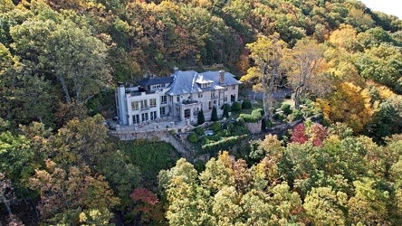
1801 Prospect Road SE
-
WTBO sign [07]
![WTBO sign [07] (2122 visits) "WTBO" in red and white channel letters at WTBO's office and transmitter site on Wills Mou... WTBO sign [07]](../../i/upload/2024/07/19/20240719185354-973f835e-cu_s9999x250.jpg)
-
Aerial view of downtown Crossville, Tennessee [02]
![Aerial view of downtown Crossville, Tennessee [02] (2132 visits) Aerial view of downtown Crossville, Tennessee.
More at The Schumin Web:
www.schuminweb.com/life-and... Aerial view of downtown Crossville, Tennessee [02]](../../i/upload/2024/07/20/20240720113738-e7992a54-cu_s9999x250.jpg)
-
WTBO sign [04]
![WTBO sign [04] (2145 visits) "WTBO" in red and white channel letters at WTBO's office and transmitter site on Wills Mou... WTBO sign [04]](../../i/upload/2024/07/19/20240719185404-2aa7c153-cu_s9999x250.jpg)
-
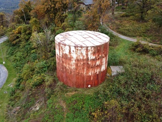
Water storage tank on Afton Mountain
-
View from High Rock around sunset [08]
![View from High Rock around sunset [08] (2221 visits) View from High Rock, a rock outcropping on South Mountain in Pen Mar, Maryland, in Washington County... View from High Rock around sunset [08]](../../i/upload/2024/07/18/20240718125539-68d743dd-cu_s9999x250.jpg)
-
View from High Rock around sunset [02]
![View from High Rock around sunset [02] (2230 visits) View from High Rock, a rock outcropping on South Mountain in Pen Mar, Maryland, in Washington County... View from High Rock around sunset [02]](../../i/upload/2024/07/18/20240718125419-06cd22f4-cu_s9999x250.jpg)
-
View from High Rock around sunset [03]
![View from High Rock around sunset [03] (2250 visits) View from High Rock, a rock outcropping on South Mountain in Pen Mar, Maryland, in Washington County... View from High Rock around sunset [03]](../../i/upload/2024/07/18/20240718125422-7938edf7-cu_s9999x250.jpg)
-
WTBO sign [05]
![WTBO sign [05] (2262 visits) "WTBO" in red and white channel letters at WTBO's office and transmitter site on Wills Mou... WTBO sign [05]](../../i/upload/2024/07/19/20240719185400-2b40bc21-cu_s9999x250.jpg)
-
View from High Rock around sunset [09]
![View from High Rock around sunset [09] (2285 visits) View from High Rock, a rock outcropping on South Mountain in Pen Mar, Maryland, in Washington County... View from High Rock around sunset [09]](../../i/upload/2024/07/18/20240718125542-d5f04008-cu_s9999x250.jpg)
-
View from 20-Minute Cliff overlook [03]
![View from 20-Minute Cliff overlook [03] (2296 visits) View from 20-Minute Cliff, an overlook on the Blue Ridge Parkway near Vesuvius, Virginia.
Ben Schum... View from 20-Minute Cliff overlook [03]](../../i/upload/2024/07/15/20240715141705-52871955-cu_s9999x250.jpg)
-
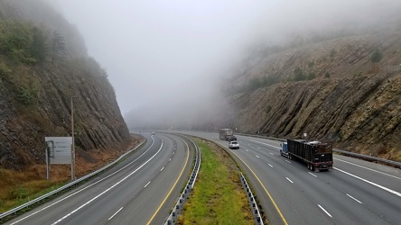
Sideling Hill cut
-
WTBO sign [06]
![WTBO sign [06] (2309 visits) "WTBO" in red and white channel letters at WTBO's office and transmitter site on Wills Mou... WTBO sign [06]](../../i/upload/2024/07/19/20240719185357-8bd08615-cu_s9999x250.jpg)
-
Footbridge over Interstate 68 at Sideling Hill [05]
![Footbridge over Interstate 68 at Sideling Hill [05] (2316 visits) Footbridge over Interstate 68 at the Sideling Hill rest area and overlook. This bridge connects the... Footbridge over Interstate 68 at Sideling Hill [05]](../../i/upload/2024/07/19/20240719185600-5a4b8c8c-cu_s9999x250.jpg)
-
The Inn at Afton, October 2020 [05]
![The Inn at Afton, October 2020 [05] (2329 visits) Aerial view of The Inn at Afton, a former 1960s-era Holiday Inn that had gone independent in the lat... The Inn at Afton, October 2020 [05]](../../i/upload/2024/07/19/20240719120656-d9775568-cu_s9999x250.jpg)
-
The Roanoke Star, October 2022 [02]
![The Roanoke Star, October 2022 [02] (2329 visits) The Roanoke Star on the afternoon of October 18, 2022.
More at The Schumin Web:
www.schuminweb.com/... The Roanoke Star, October 2022 [02]](../../i/upload/2024/07/20/20240720121843-dd3a2c06-cu_s9999x250.jpg)
-
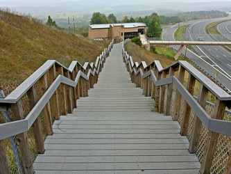
Stairs from Sideling Hill overlook
-
View from High Rock around sunset [10]
![View from High Rock around sunset [10] (2334 visits) View from High Rock, a rock outcropping on South Mountain in Pen Mar, Maryland, in Washington County... View from High Rock around sunset [10]](../../i/upload/2024/07/18/20240718125546-0de77111-cu_s9999x250.jpg)
-
Footbridge over Interstate 68 at Sideling Hill [04]
![Footbridge over Interstate 68 at Sideling Hill [04] (2341 visits) Footbridge over Interstate 68 at the Sideling Hill rest area and overlook. This bridge connects the... Footbridge over Interstate 68 at Sideling Hill [04]](../../i/upload/2024/07/19/20240719185606-500553a9-cu_s9999x250.jpg)
-
Stream at Yankee Horse Ridge [01]
![Stream at Yankee Horse Ridge [01] (2347 visits) Stream with small waterfall at the Yankee Horse Ridge overlook, on the Blue Ridge Parkway near Monte... Stream at Yankee Horse Ridge [01]](../../i/upload/2024/07/15/20240715141709-62daf30c-cu_s9999x250.jpg)
-
Footbridge over Interstate 68 at Sideling Hill [03]
![Footbridge over Interstate 68 at Sideling Hill [03] (2364 visits) Footbridge over Interstate 68 at the Sideling Hill rest area and overlook. This bridge connects the... Footbridge over Interstate 68 at Sideling Hill [03]](../../i/upload/2024/07/19/20240719185610-547a3ae0-cu_s9999x250.jpg)
-
Footbridge over Interstate 68 at Sideling Hill [06]
![Footbridge over Interstate 68 at Sideling Hill [06] (2369 visits) Footbridge over Interstate 68 at the Sideling Hill rest area and overlook. This bridge connects the... Footbridge over Interstate 68 at Sideling Hill [06]](../../i/upload/2024/07/19/20240719185550-ad4c16ff-cu_s9999x250.jpg)
-
The Inn at Afton, October 2020 [06]
![The Inn at Afton, October 2020 [06] (2396 visits) Aerial view of The Inn at Afton, a former 1960s-era Holiday Inn that had gone independent in the lat... The Inn at Afton, October 2020 [06]](../../i/upload/2024/07/19/20240719120701-60d20afa-cu_s9999x250.jpg)
-
The Roanoke Star, October 2022 [01]
![The Roanoke Star, October 2022 [01] (2410 visits) The Roanoke Star on the afternoon of October 18, 2022.
More at The Schumin Web:
www.schuminweb.com/... The Roanoke Star, October 2022 [01]](../../i/upload/2024/07/20/20240720121819-a9caaaf4-cu_s9999x250.jpg)
-
Remains of a teepee near Rockfish Gap [01]
![Remains of a teepee near Rockfish Gap [01] (2418 visits) Remains of a teepee made out of sticks near Rockfish Gap, just north of Interstate 64. This teepee ... Remains of a teepee near Rockfish Gap [01]](../../i/upload/2024/07/19/20240719120203-29e8f620-cu_s9999x250.jpg)
-
Stream at Yankee Horse Ridge [01]
![Stream at Yankee Horse Ridge [01] (2432 visits) Stream with small waterfall at the Yankee Horse Ridge overlook, on the Blue Ridge Parkway near Monte... Stream at Yankee Horse Ridge [01]](../../i/upload/2024/07/15/20240715141706-0b231326-cu_s9999x250.jpg)
-
Stream at Yankee Horse Ridge [01]
![Stream at Yankee Horse Ridge [01] (2440 visits) Stream with small waterfall at the Yankee Horse Ridge overlook, on the Blue Ridge Parkway near Monte... Stream at Yankee Horse Ridge [01]](../../i/upload/2024/07/15/20240715141708-6e96c46a-cu_s9999x250.jpg)
-
Remains of a teepee near Rockfish Gap [03]
![Remains of a teepee near Rockfish Gap [03] (2444 visits) Remains of a teepee made out of sticks near Rockfish Gap, just north of Interstate 64. This teepee ... Remains of a teepee near Rockfish Gap [03]](../../i/upload/2024/07/19/20240719120522-9cfca1b5-cu_s9999x250.jpg)
-
Remains of a teepee near Rockfish Gap [02]
![Remains of a teepee near Rockfish Gap [02] (2457 visits) Remains of a teepee made out of sticks near Rockfish Gap, just north of Interstate 64. This teepee ... Remains of a teepee near Rockfish Gap [02]](../../i/upload/2024/07/19/20240719120510-b86f0eb9-cu_s9999x250.jpg)
-
View from High Rock around sunset [11]
![View from High Rock around sunset [11] (2459 visits) View from High Rock, a rock outcropping on South Mountain in Pen Mar, Maryland, in Washington County... View from High Rock around sunset [11]](../../i/upload/2024/07/18/20240718125550-f940cb2a-cu_s9999x250.jpg)
-
View from the Roanoke Star, October 2022 [02]
![View from the Roanoke Star, October 2022 [02] (2464 visits) View of Roanoke, Virginia from Mill Mountain, October 18, 2022.
More at The Schumin Web:
www.schumi... View from the Roanoke Star, October 2022 [02]](../../i/upload/2024/07/20/20240720121946-ef64a8e5-cu_s9999x250.jpg)
-
View of the sunset from High Rock [02]
![View of the sunset from High Rock [02] (2467 visits) View of the sunset from High Rock, a rock outcropping on South Mountain in Pen Mar, Maryland, in Was... View of the sunset from High Rock [02]](../../i/upload/2024/07/18/20240718125557-d168466e-cu_s9999x250.jpg)
-
Remains of a teepee near Rockfish Gap [06]
![Remains of a teepee near Rockfish Gap [06] (2470 visits) Remains of a teepee made out of sticks near Rockfish Gap, just north of Interstate 64. This teepee ... Remains of a teepee near Rockfish Gap [06]](../../i/upload/2024/07/19/20240719120546-d258fa0c-cu_s9999x250.jpg)
-
Remains of a teepee near Rockfish Gap [05]
![Remains of a teepee near Rockfish Gap [05] (2471 visits) Remains of a teepee made out of sticks near Rockfish Gap, just north of Interstate 64. This teepee ... Remains of a teepee near Rockfish Gap [05]](../../i/upload/2024/07/19/20240719120534-844e7621-cu_s9999x250.jpg)
-
View from the Roanoke Star, October 2022 [03]
![View from the Roanoke Star, October 2022 [03] (2479 visits) View of Roanoke, Virginia from Mill Mountain, October 18, 2022.
More at The Schumin Web:
www.schumi... View from the Roanoke Star, October 2022 [03]](../../i/upload/2024/07/20/20240720121951-aad25312-cu_s9999x250.jpg)
-
Remains of a teepee near Rockfish Gap [04]
![Remains of a teepee near Rockfish Gap [04] (2491 visits) Remains of a teepee made out of sticks near Rockfish Gap, just north of Interstate 64. This teepee ... Remains of a teepee near Rockfish Gap [04]](../../i/upload/2024/07/19/20240719120530-df561881-cu_s9999x250.jpg)
-
The Inn at Afton, October 2020 [01]
![The Inn at Afton, October 2020 [01] (2496 visits) Aerial view of The Inn at Afton, a former 1960s-era Holiday Inn that had gone independent in the lat... The Inn at Afton, October 2020 [01]](../../i/upload/2024/07/19/20240719120633-24efa0d6-cu_s9999x250.jpg)
-
View from the Roanoke Star, October 2022 [04]
![View from the Roanoke Star, October 2022 [04] (2507 visits) View of Roanoke, Virginia from Mill Mountain, October 18, 2022.
More at The Schumin Web:
www.schumi... View from the Roanoke Star, October 2022 [04]](../../i/upload/2024/07/20/20240720121957-f438f2a3-cu_s9999x250.jpg)
-
Stream at Yankee Horse Ridge [01]
![Stream at Yankee Horse Ridge [01] (2524 visits) Stream with small waterfall at the Yankee Horse Ridge overlook, on the Blue Ridge Parkway near Monte... Stream at Yankee Horse Ridge [01]](../../i/upload/2024/07/15/20240715141714-3facf0fc-cu_s9999x250.jpg)
-
View of the sunset from High Rock [01]
![View of the sunset from High Rock [01] (2531 visits) View of the sunset from High Rock, a rock outcropping on South Mountain in Pen Mar, Maryland, in Was... View of the sunset from High Rock [01]](../../i/upload/2024/07/18/20240718125553-1df4c653-cu_s9999x250.jpg)
-
View of the sunset from High Rock [03]
![View of the sunset from High Rock [03] (2544 visits) View of the sunset from High Rock, a rock outcropping on South Mountain in Pen Mar, Maryland, in Was... View of the sunset from High Rock [03]](../../i/upload/2024/07/18/20240718125601-a2d71104-cu_s9999x250.jpg)
-
Aerial view of Roanoke, Virginia [06]
![Aerial view of Roanoke, Virginia [06] (2576 visits) Aerial view of Roanoke, Virginia.
More at The Schumin Web:
www.schuminweb.com/life-and-times/advent... Aerial view of Roanoke, Virginia [06]](../../i/upload/2024/07/20/20240720121917-3d4a6311-cu_s9999x250.jpg)
-
Aerial view of Roanoke, Virginia [02]
![Aerial view of Roanoke, Virginia [02] (2641 visits) Aerial view of Roanoke, Virginia.
More at The Schumin Web:
www.schuminweb.com/life-and-times/advent... Aerial view of Roanoke, Virginia [02]](../../i/upload/2024/07/20/20240720121808-dccb83a0-cu_s9999x250.jpg)
-
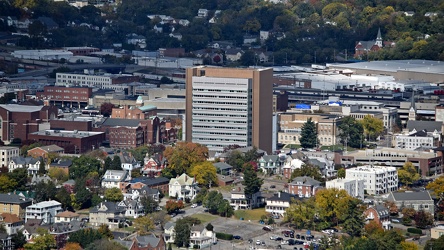
Poff Federal Building, viewed from Mill Mountain
-
Stream at Yankee Horse Ridge [01]
![Stream at Yankee Horse Ridge [01] (2688 visits) Stream with small waterfall at the Yankee Horse Ridge overlook, on the Blue Ridge Parkway near Monte... Stream at Yankee Horse Ridge [01]](../../i/upload/2024/07/15/20240715141711-08c8936c-cu_s9999x250.jpg)
-
Aerial view of Roanoke, Virginia [03]
![Aerial view of Roanoke, Virginia [03] (2728 visits) Aerial view of Roanoke, Virginia.
More at The Schumin Web:
www.schuminweb.com/life-and-times/advent... Aerial view of Roanoke, Virginia [03]](../../i/upload/2024/07/20/20240720121837-3c6bbb13-cu_s9999x250.jpg)
-
Aerial view of Roanoke, Virginia [05]
![Aerial view of Roanoke, Virginia [05] (2730 visits) Aerial view of Roanoke, Virginia.
More at The Schumin Web:
www.schuminweb.com/life-and-times/advent... Aerial view of Roanoke, Virginia [05]](../../i/upload/2024/07/20/20240720121906-5f802cee-cu_s9999x250.jpg)
 Sideling Hill rest area [06]
![Sideling Hill rest area [06] (2736 visits) Stairs to a raised viewing area on the eastbound side of the Sideling Hill rest area, located along ... Sideling Hill rest area [06]](../../i/upload/2024/07/17/20240717233527-43e4656c-cu_s9999x250.jpg)
-
Aerial view of Roanoke, Virginia [01]
![Aerial view of Roanoke, Virginia [01] (2736 visits) Aerial view of Roanoke, Virginia.
More at The Schumin Web:
www.schuminweb.com/life-and-times/advent... Aerial view of Roanoke, Virginia [01]](../../i/upload/2024/07/20/20240720121757-bb58476c-cu_s9999x250.jpg)
 Sideling Hill rest area [03]
![Sideling Hill rest area [03] (2739 visits) Footbridge across Interstate 68, allowing views of the cut through the mountain, at the Sideling Hil... Sideling Hill rest area [03]](../../i/upload/2024/07/17/20240717233511-e61616ff-cu_s9999x250.jpg)
-
Graffiti-covered stone at High Rock [03]
![Graffiti-covered stone at High Rock [03] (2752 visits) Graffiti-covered stone at High Rock, a rock outcropping on South Mountain in Pen Mar, Maryland, in W... Graffiti-covered stone at High Rock [03]](../../i/upload/2024/07/18/20240718125500-5ab7b0f5-cu_s9999x250.jpg)
-
Aerial view of Roanoke, Virginia [04]
![Aerial view of Roanoke, Virginia [04] (2787 visits) Aerial view of Roanoke, Virginia.
More at The Schumin Web:
www.schuminweb.com/life-and-times/advent... Aerial view of Roanoke, Virginia [04]](../../i/upload/2024/07/20/20240720121854-34748718-cu_s9999x250.jpg)
-
Graffiti-covered stones at High Rock

-
View from High Rock around sunset [05]
![View from High Rock around sunset [05] (2810 visits) View from High Rock, a rock outcropping on South Mountain in Pen Mar, Maryland, in Washington County... View from High Rock around sunset [05]](../../i/upload/2024/07/18/20240718125445-9b7d8206-cu_s9999x250.jpg)
-
Graffiti-covered stone at High Rock [04]
![Graffiti-covered stone at High Rock [04] (2811 visits) Graffiti-covered stone at High Rock, a rock outcropping on South Mountain in Pen Mar, Maryland, in W... Graffiti-covered stone at High Rock [04]](../../i/upload/2024/07/18/20240718125505-6e88d549-cu_s9999x250.jpg)
-
View from High Rock around sunset [04]
![View from High Rock around sunset [04] (2814 visits) View from High Rock, a rock outcropping on South Mountain in Pen Mar, Maryland, in Washington County... View from High Rock around sunset [04]](../../i/upload/2024/07/18/20240718125433-8a060ae7-cu_s9999x250.jpg)
-
View from High Rock around sunset [07]
![View from High Rock around sunset [07] (2835 visits) View from High Rock, a rock outcropping on South Mountain in Pen Mar, Maryland, in Washington County... View from High Rock around sunset [07]](../../i/upload/2024/07/18/20240718125452-a060fd82-cu_s9999x250.jpg)
-
Graffiti-covered stone at High Rock [02]
![Graffiti-covered stone at High Rock [02] (2838 visits) Graffiti-covered stone at High Rock, a rock outcropping on South Mountain in Pen Mar, Maryland, in W... Graffiti-covered stone at High Rock [02]](../../i/upload/2024/07/18/20240718125456-e62dc4ce-cu_s9999x250.jpg)
-
The Inn at Afton, October 2020 [03]
![The Inn at Afton, October 2020 [03] (2863 visits) Aerial view of The Inn at Afton, a former 1960s-era Holiday Inn that had gone independent in the lat... The Inn at Afton, October 2020 [03]](../../i/upload/2024/07/19/20240719120647-d0f91240-cu_s9999x250.jpg)