
Ben Schumin Photography Portfolio
Ben Schumin is a professional photographer who captures the intricacies of daily life.
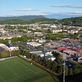
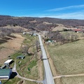
Aerial view of an area around US 13 in Pocomoke City, Maryland in late afternoon.
![RFK Stadium, viewed from the Metro [01]](../../../i/upload/2024/07/14/20240714234811-bd2a3e47-sq.jpg)
![RFK Stadium, viewed from the Metro [02]](../../../i/upload/2024/07/16/20240716010728-79280d0c-sq.jpg)

![Barbed wire in Laytonsville, Maryland [01]](../../../i/upload/2024/07/17/20240717224812-778e3f3c-sq.jpg)

![Interior of Owings Mills Mall [06]](../../../i/upload/2024/07/18/20240718125925-b22318ca-sq.jpg)
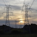
![Power transmission lines in Frederick County [02]](../../../i/upload/2024/07/19/20240719093429-9f31f834-sq.jpg)
![Power transmission lines in Frederick County [01]](../../../i/upload/2024/07/19/20240719093435-6cd9373f-sq.jpg)
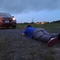
![Honda HR-V in a field near Martinsburg [01]](../../../i/upload/2024/07/19/20240719103523-10c96365-sq.jpg)
![Honda HR-V in a field near Martinsburg [02]](../../../i/upload/2024/07/19/20240719103527-190606e6-sq.jpg)
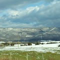
![Myersville, Maryland and vicinity [01]](../../../i/upload/2024/07/19/20240719114529-b09266dc-sq.jpg)
![Barbed wire in Laytonsville, Maryland [02]](../../../i/upload/2024/07/19/20240719114810-85a21e17-sq.jpg)
![Stuarts Draft High School stadium [01]](../../../i/upload/2024/07/19/20240719120538-9a5d4af4-sq.jpg)
![Stuarts Draft High School stadium [02]](../../../i/upload/2024/07/19/20240719160900-258e5b1f-sq.jpg)
![Field south of Waynesboro Town Center [02]](../../../i/upload/2024/07/19/20240719164011-bfef621f-sq.jpg)
![Field south of Waynesboro Town Center [03]](../../../i/upload/2024/07/19/20240719164113-3872f41a-sq.jpg)
![Field south of Waynesboro Town Center [01]](../../../i/upload/2024/07/19/20240719164131-8c6e4a64-sq.jpg)
![Buffalo Gap [01]](../../../i/upload/2024/07/19/20240719164455-62064f1c-sq.jpg)
![Buffalo Gap High School [01]](../../../i/upload/2024/07/19/20240719164459-267a0d43-sq.jpg)
![Buffalo Gap High School [02]](../../../i/upload/2024/07/19/20240719164505-bdd29e59-sq.jpg)
![Buffalo Gap High School [03]](../../../i/upload/2024/07/19/20240719164509-fab8ad49-sq.jpg)
![Buffalo Gap High School [04]](../../../i/upload/2024/07/19/20240719164514-e0a1e82e-sq.jpg)
![Buffalo Gap High School [05]](../../../i/upload/2024/07/19/20240719164519-518a0909-sq.jpg)
![Buffalo Gap High School [06]](../../../i/upload/2024/07/19/20240719164523-e9a7db09-sq.jpg)
![Fairfield, Pennsylvania [02]](../../../i/upload/2024/07/19/20240719170855-9f47cc5b-sq.jpg)
![Sunset near Gettysburg, Pennsylvania [01]](../../../i/upload/2024/07/19/20240719170930-530c41ea-sq.jpg)
![Sunset near Gettysburg, Pennsylvania [02]](../../../i/upload/2024/07/19/20240719170934-9483611c-sq.jpg)
![Field of cotton in Goldsboro, North Carolina [01]](../../../i/upload/2024/07/19/20240719200140-3f2f49c8-sq.jpg)
![Field of cotton in Goldsboro, North Carolina [02]](../../../i/upload/2024/07/19/20240719200819-151fba02-sq.jpg)
![Field of cotton in Goldsboro, North Carolina [03]](../../../i/upload/2024/07/19/20240719200833-9b953c76-sq.jpg)
![Field of cotton in Goldsboro, North Carolina [04]](../../../i/upload/2024/07/19/20240719200856-4b8302ec-sq.jpg)
![Field of cotton in Goldsboro, North Carolina [05]](../../../i/upload/2024/07/19/20240719200901-3ad6c5f2-sq.jpg)
![Field of cotton in Goldsboro, North Carolina [06]](../../../i/upload/2024/07/19/20240719200927-92c721b1-sq.jpg)
![Field of cotton in Goldsboro, North Carolina [07]](../../../i/upload/2024/07/19/20240719200932-11eb34e8-sq.jpg)
![Field of cotton in Goldsboro, North Carolina [08]](../../../i/upload/2024/07/19/20240719200945-18ed26c5-sq.jpg)
![Field of cotton in Goldsboro, North Carolina [09]](../../../i/upload/2024/07/19/20240719200959-775444c5-sq.jpg)
![Field of cotton in Goldsboro, North Carolina [10]](../../../i/upload/2024/07/19/20240719201008-d30d3329-sq.jpg)
![Field of cotton in Goldsboro, North Carolina [11]](../../../i/upload/2024/07/19/20240719201013-cca7f6a8-sq.jpg)
![Field of cotton in Goldsboro, North Carolina [12]](../../../i/upload/2024/07/19/20240719201019-0510e072-sq.jpg)
![Field of cotton in Goldsboro, North Carolina [13]](../../../i/upload/2024/07/19/20240719201023-cf0514ea-sq.jpg)
![Field of cotton in Goldsboro, North Carolina [14]](../../../i/upload/2024/07/19/20240719201028-54607776-sq.jpg)
![Field of cotton in Goldsboro, North Carolina [15]](../../../i/upload/2024/07/19/20240719201034-cbf04685-sq.jpg)
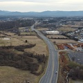
![Interstate 81 at Route 796 [02]](../../../i/upload/2024/07/20/20240720020830-706bf71d-sq.jpg)
![Interstate 81 at Route 796 [01]](../../../i/upload/2024/07/20/20240720020902-02c4ce7b-sq.jpg)
![Payphone in Head Waters, Virginia [01]](../../../i/upload/2024/07/20/20240720094301-6db6c91c-sq.jpg)
![Payphone in Head Waters, Virginia [02]](../../../i/upload/2024/07/20/20240720094306-5ef3c0a3-sq.jpg)
![Stuarts Draft, Virginia above Wayne Avenue [02]](../../../i/upload/2024/07/20/20240720094514-88dd2f1e-sq.jpg)
![Stuarts Draft, Virginia above Wayne Avenue [01]](../../../i/upload/2024/07/20/20240720094536-55029349-sq.jpg)
![Stuarts Draft, Virginia above Wayne Avenue [03]](../../../i/upload/2024/07/20/20240720094705-d02b94dc-sq.jpg)
![Stuarts Draft, Virginia above Wayne Avenue [05]](../../../i/upload/2024/07/20/20240720094711-10b1bf16-sq.jpg)
![Stuarts Draft, Virginia above Wayne Avenue [04]](../../../i/upload/2024/07/20/20240720094817-ef62e5b8-sq.jpg)
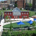
![Thomas Jefferson School No. 1 [01]](../../../i/upload/2024/07/20/20240720151402-7377c838-sq.jpg)
![Thomas Jefferson School No. 1 [02]](../../../i/upload/2024/07/20/20240720151630-5714f697-sq.jpg)
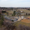
![Field off of Buchanan Valley Road [01]](../../../i/upload/2024/07/20/20240720151904-0d791d12-sq.jpg)
![Field off of Buchanan Valley Road [02]](../../../i/upload/2024/07/20/20240720151916-e473a17f-sq.jpg)
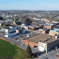
![Aerial view of Smithsburg, Maryland [01]](../../../i/upload/2024/07/20/20240720155756-7d354d6c-sq.jpg)
![Aerial view of Smithsburg, Maryland [02]](../../../i/upload/2024/07/20/20240720155800-cb15da92-sq.jpg)
![Aerial view of Smithsburg, Maryland [03]](../../../i/upload/2024/07/20/20240720155805-a9f3e7ed-sq.jpg)

![Aerial view of Fort Defiance, Virginia [02]](../../../i/upload/2024/11/27/20241127094254-f1257220-sq.jpg)
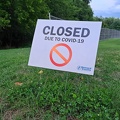
![No parking sign at Verona Elementary School [01]](../../../i/upload/2024/11/28/20241128101631-4603ef75-sq.jpg)
![No parking sign at Verona Elementary School [02]](../../../i/upload/2024/11/28/20241128101653-4da78d8d-sq.jpg)
![No parking sign at Verona Elementary School [03]](../../../i/upload/2024/11/28/20241128101738-fd085a6e-sq.jpg)
![No parking sign at Verona Elementary School [04]](../../../i/upload/2024/11/28/20241128101836-aaf70cee-sq.jpg)

![Riverheads High School [01]](../../../i/upload/2024/11/28/20241128234210-f98993d4-sq.jpg)
![Riverheads High School [02]](../../../i/upload/2024/11/28/20241128234228-4c25b70c-sq.jpg)
![Riverheads High School [03]](../../../i/upload/2024/11/28/20241128234243-f9e0eb91-sq.jpg)
![Riverheads High School [04]](../../../i/upload/2024/11/28/20241128234325-619d414c-sq.jpg)
![Riverheads High School [05]](../../../i/upload/2024/11/28/20241128234415-0312a92c-sq.jpg)
![Riverheads High School [06]](../../../i/upload/2024/11/28/20241128234509-7a78f401-sq.jpg)
![Riverheads High School [07]](../../../i/upload/2024/11/28/20241128234645-fb85ca2b-sq.jpg)
![Riverheads High School [08]](../../../i/upload/2024/11/28/20241128234810-2bcf854e-sq.jpg)
![Riverheads High School [09]](../../../i/upload/2024/11/28/20241128234835-01536756-sq.jpg)
![Riverheads High School [10]](../../../i/upload/2024/11/28/20241128234922-4572527a-sq.jpg)
![Riverheads High School [11]](../../../i/upload/2024/11/28/20241128235104-1b760647-sq.jpg)
![Riverheads High School [12]](../../../i/upload/2024/11/28/20241128235124-6c00f637-sq.jpg)
![Riverheads High School [13]](../../../i/upload/2024/11/28/20241128235208-34d335d7-sq.jpg)
![Riverheads High School [14]](../../../i/upload/2024/11/28/20241128235305-d6e62632-sq.jpg)

![Paint Branch High School [01]](../../../i/upload/2024/12/22/20241222233144-0183c8e4-sq.jpg)
![Paint Branch High School [02]](../../../i/upload/2024/12/22/20241222233150-8fe398b9-sq.jpg)
![Paint Branch High School [03]](../../../i/upload/2024/12/22/20241222233155-1e477559-sq.jpg)
![Paint Branch High School [04]](../../../i/upload/2024/12/22/20241222233200-eb8b0005-sq.jpg)
![Paint Branch High School [05]](../../../i/upload/2024/12/22/20241222233206-d3bf483b-sq.jpg)
![Paint Branch High School [06]](../../../i/upload/2024/12/22/20241222233211-7e20b805-sq.jpg)
![Paint Branch High School [07]](../../../i/upload/2024/12/22/20241222233218-3031714a-sq.jpg)
![Paint Branch High School [08]](../../../i/upload/2024/12/22/20241222233223-5cdc71cd-sq.jpg)
![Paint Branch High School [11]](../../../i/upload/2024/12/22/20241222233237-dd57e6bd-sq.jpg)
![Paint Branch High School [12]](../../../i/upload/2024/12/22/20241222233241-81d5ed18-sq.jpg)
![Paint Branch High School [13]](../../../i/upload/2024/12/22/20241222233246-0ecb0ec8-sq.jpg)
![Paint Branch High School [14]](../../../i/upload/2024/12/22/20241222233251-1bc4d348-sq.jpg)
![Paint Branch High School [15]](../../../i/upload/2024/12/22/20241222233255-418f1029-sq.jpg)
![Paint Branch High School [16]](../../../i/upload/2024/12/22/20241222233259-713b2718-sq.jpg)
![Paint Branch High School [17]](../../../i/upload/2024/12/22/20241222233304-e492dd5c-sq.jpg)
![Paint Branch High School [18]](../../../i/upload/2024/12/22/20241222233311-d0850ecc-sq.jpg)


![Buffalo Gap [02]](../../../i/upload/2025/01/03/20250103200607-1abe8192-sq.jpg)
![Buffalo Gap Middle and High Schools [01]](../../../i/upload/2025/01/03/20250103202026-5cdc496f-sq.jpg)
![Buffalo Gap Middle and High Schools [02]](../../../i/upload/2025/01/03/20250103202032-55e71413-sq.jpg)
![Buffalo Gap Middle and High Schools [03]](../../../i/upload/2025/01/03/20250103202038-0ede0383-sq.jpg)
![Buffalo Gap Middle and High Schools [04]](../../../i/upload/2025/01/03/20250103202044-b8863daf-sq.jpg)
![Buffalo Gap Middle and High Schools [05]](../../../i/upload/2025/01/03/20250103202050-4b55d57a-sq.jpg)
![Buffalo Gap Middle and High Schools [06]](../../../i/upload/2025/01/03/20250103202056-3a028545-sq.jpg)
![Buffalo Gap Middle and High Schools [07]](../../../i/upload/2025/01/03/20250103202103-2963fcc1-sq.jpg)
![Buffalo Gap Middle and High Schools [08]](../../../i/upload/2025/01/03/20250103202111-0d42bedb-sq.jpg)
![Buffalo Gap Middle and High Schools [09]](../../../i/upload/2025/01/03/20250103202117-3e1c51f7-sq.jpg)
![Buffalo Gap Middle and High Schools [10]](../../../i/upload/2025/01/03/20250103202123-a70709f6-sq.jpg)
![Area around US 13 in Pocomoke City, Maryland [01]](../../../i/upload/2025/02/16/20250216104958-9cfd679e-sq.jpg)
![Area around US 13 in Pocomoke City, Maryland [02]](../../../i/upload/2025/02/16/20250216105020-45970493-sq.jpg)
![Zable Stadium and Cary Field [01]](../../../i/upload/2025/02/22/20250222000929-3373536a-sq.jpg)
![Zable Stadium and Cary Field [02]](../../../i/upload/2025/02/22/20250222000936-370ac2e6-sq.jpg)

![Aerial view of Wayne Community College [01]](../../../i/upload/2025/03/10/20250310201548-58e9769c-sq.jpg)
![Aerial view of Wayne Community College [02]](../../../i/upload/2025/03/10/20250310201556-3666ee50-sq.jpg)
![Aerial view of Wayne Community College [03]](../../../i/upload/2025/03/10/20250310201604-518deba5-sq.jpg)
![Aerial view of Wayne Community College [04]](../../../i/upload/2025/03/10/20250310201611-4991f2f2-sq.jpg)
Information
- Author
- Ben Schumin
- Copyright
- All Rights Reserved
- Created on
- Thursday 30 May 2024
- Dimensions
- 8064*4536
EXIF Metadata
DJI FC8282
f/170/100
1/5000
200
0/10
0
- DateTimeOriginal
- 2024:05:30 19:03:24
- DateTimeDigitized
- 2024:05:30 19:03:24
- Make
- DJI
- Model
- FC8282
- ExposureProgram
- 2
- FocalLengthIn35mmFilm
- 24
- FNumber
- 170/100
- ExposureTime
- 1/5000
- ISOSpeedRatings
- 200
- Flash
- 0
- WhiteBalance
- 0
- XResolution
- 720000/10000
- YResolution
- 720000/10000
- ImageWidth
- 8064
- ImageLength
- 4536
- Orientation
- 1
- SamplesPerPixel
- 3
- ExposureBiasValue
- 0/10
- MaxApertureValue
- 153/100
- MeteringMode
- 1
- LightSource
- 1
Powered by Piwigo