
Ben Schumin Photography Portfolio
Ben Schumin is a professional photographer who captures the intricacies of daily life.
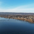
Aerial view of an area around US 13 in Pocomoke City, Maryland in late afternoon.

![Graffiti Highway, facing north [01]](../../../i/upload/2024/07/18/20240718225558-c6e9a1b0-sq.jpg)
![Graffiti Highway, facing north [02]](../../../i/upload/2024/07/18/20240718225602-ab6789e9-sq.jpg)


![Abandoned couch on the Graffiti Highway [01]](../../../i/upload/2024/07/18/20240718225620-48e1e837-sq.jpg)

![Graffiti Highway, facing north [03]](../../../i/upload/2024/07/18/20240718225628-4b07e821-sq.jpg)
![Graffiti Highway, facing north [04]](../../../i/upload/2024/07/18/20240718225632-bf35d5b7-sq.jpg)
![Discarded spray paint can [01]](../../../i/upload/2024/07/18/20240718225636-aa2c3309-sq.jpg)
![Discarded spray paint can [02]](../../../i/upload/2024/07/18/20240718225641-34818498-sq.jpg)
![Discarded spray paint can [03]](../../../i/upload/2024/07/18/20240718225645-3a06728f-sq.jpg)
![Discarded spray paint can [04]](../../../i/upload/2024/07/18/20240718225649-1bbd1d03-sq.jpg)
![Discarded spray paint can [05]](../../../i/upload/2024/07/18/20240718225653-7a6d2dca-sq.jpg)
![Discarded spray paint can [06]](../../../i/upload/2024/07/18/20240718225658-641e6183-sq.jpg)
![Discarded spray paint can [07]](../../../i/upload/2024/07/18/20240718225703-187d89a8-sq.jpg)
![Discarded spray paint can [08]](../../../i/upload/2024/07/18/20240718225707-984f96a6-sq.jpg)
![Discarded spray paint can [09]](../../../i/upload/2024/07/18/20240718225711-81f404b9-sq.jpg)
![Discarded spray paint can [10]](../../../i/upload/2024/07/18/20240718225715-cb6bcbc7-sq.jpg)

![Southern end of Graffiti Highway [01]](../../../i/upload/2024/07/18/20240718225724-3e8c1137-sq.jpg)
![Southern end of Graffiti Highway [02]](../../../i/upload/2024/07/18/20240718225728-609ba646-sq.jpg)

![Graffiti Highway, facing north [05]](../../../i/upload/2024/07/18/20240718225737-7169f5fc-sq.jpg)


![Graffiti Highway, facing north [06]](../../../i/upload/2024/07/18/20240718225754-579e69e2-sq.jpg)
![Discarded spray paint can [11]](../../../i/upload/2024/07/18/20240718225758-e72a0020-sq.jpg)


![Graffiti Highway, facing north [07]](../../../i/upload/2024/07/18/20240718225819-1aefe767-sq.jpg)
![Discarded spray paint can [12]](../../../i/upload/2024/07/18/20240718225827-06efaa69-sq.jpg)
![Discarded spray paint can [13]](../../../i/upload/2024/07/18/20240718225833-07a91c25-sq.jpg)
![Discarded spray paint can [14]](../../../i/upload/2024/07/18/20240718225839-c4c2a4ba-sq.jpg)
![Discarded spray paint can [15]](../../../i/upload/2024/07/18/20240718225843-21462d12-sq.jpg)
![Discarded spray paint can [16]](../../../i/upload/2024/07/18/20240718225847-cfa75596-sq.jpg)
![Discarded spray paint can [17]](../../../i/upload/2024/07/18/20240718225852-a306f2f2-sq.jpg)


![Abandoned couch on the Graffiti Highway [02]](../../../i/upload/2024/07/18/20240718225907-1ef187b6-sq.jpg)
![Abandoned couch on the Graffiti Highway [03]](../../../i/upload/2024/07/18/20240718225912-067b9cb0-sq.jpg)
![Flag in a crack in the pavement [03]](../../../i/upload/2024/07/18/20240718225917-de0cdf19-sq.jpg)
![Flag in a crack in the pavement [02]](../../../i/upload/2024/07/18/20240718225922-f3938677-sq.jpg)
![Flag in a crack in the pavement [01]](../../../i/upload/2024/07/18/20240718225926-abaf5102-sq.jpg)
![Abandoned couch on the Graffiti Highway [04]](../../../i/upload/2024/07/18/20240718225930-2688196a-sq.jpg)
![Abandoned couch on the Graffiti Highway [05]](../../../i/upload/2024/07/18/20240718225934-01f6631d-sq.jpg)
![Graffiti Highway, facing south [01]](../../../i/upload/2024/07/18/20240718225939-ffe02c6c-sq.jpg)
![Graffiti Highway, facing south [02]](../../../i/upload/2024/07/18/20240718225943-e55125b5-sq.jpg)
![Graffiti Highway, facing north [08]](../../../i/upload/2024/07/18/20240718225947-44e2fb69-sq.jpg)
![Abandoned couch on the roadside [01]](../../../i/upload/2024/07/18/20240718225951-3c3189cf-sq.jpg)
![Abandoned couch on the roadside [02]](../../../i/upload/2024/07/18/20240718225955-c0a51e89-sq.jpg)
![Rift in the former Route 61 [03]](../../../i/upload/2024/07/18/20240718225959-fff57211-sq.jpg)
![Rift in the former Route 61 [02]](../../../i/upload/2024/07/18/20240718230003-4ef764d7-sq.jpg)
![Rift in the former Route 61 [01]](../../../i/upload/2024/07/18/20240718230008-295c1e8f-sq.jpg)

![Graffiti Highway, facing north [09]](../../../i/upload/2024/07/18/20240718230018-9f76d664-sq.jpg)


![Graffiti Highway, facing south [03]](../../../i/upload/2024/07/18/20240718230031-1484ae1e-sq.jpg)
![Graffiti Highway, facing south [04]](../../../i/upload/2024/07/18/20240718230035-f2f31187-sq.jpg)

![Graffiti Highway, facing north [10]](../../../i/upload/2024/07/18/20240718230044-cba65c9e-sq.jpg)
![Graffiti Highway, facing south [05]](../../../i/upload/2024/07/18/20240718230048-93f5de9a-sq.jpg)
![Graffiti Highway, facing north [11]](../../../i/upload/2024/07/18/20240718230052-b88efaef-sq.jpg)

![Discarded spray paint can [18]](../../../i/upload/2024/07/18/20240718230100-ae49da6c-sq.jpg)


![Graffiti Highway, facing south [06]](../../../i/upload/2024/07/18/20240718230114-5b0682ab-sq.jpg)


![Graffiti Highway, facing south [07]](../../../i/upload/2024/07/18/20240718230139-fd091e0c-sq.jpg)

![Graffiti-covered tree [01]](../../../i/upload/2024/07/18/20240718230148-527a7844-sq.jpg)

![Graffiti-covered tree [02]](../../../i/upload/2024/07/18/20240718230157-b273d8a3-sq.jpg)


![James River Bridge [04]](../../../i/upload/2024/07/19/20240719202325-4257c4a3-sq.jpg)
![James River Bridge [05]](../../../i/upload/2024/07/19/20240719202330-be52e801-sq.jpg)
![Windward Towers and Leeward Marina [02]](../../../i/upload/2024/07/19/20240719202335-9d3149ac-sq.jpg)
![James River Bridge [03]](../../../i/upload/2024/07/19/20240719202529-b0e807ab-sq.jpg)
![James River Bridge [08]](../../../i/upload/2024/07/19/20240719202534-7843f0b6-sq.jpg)
![James River Bridge [09]](../../../i/upload/2024/07/19/20240719202539-877160be-sq.jpg)
![James River Bridge [06]](../../../i/upload/2024/07/19/20240719202642-04c26af8-sq.jpg)
![James River Bridge [07]](../../../i/upload/2024/07/19/20240719202647-27533348-sq.jpg)
![James River Bridge [11]](../../../i/upload/2024/07/19/20240719202653-8658db60-sq.jpg)
![James River Bridge [02]](../../../i/upload/2024/07/19/20240719202733-9fb73a13-sq.jpg)
![James River Bridge [10]](../../../i/upload/2024/07/19/20240719202742-6238cd7f-sq.jpg)
![Windward Towers and Leeward Marina [01]](../../../i/upload/2024/07/19/20240719202747-251158fb-sq.jpg)
![James River Bridge [01]](../../../i/upload/2024/07/19/20240719202759-cb89473a-sq.jpg)
![James River Bridge from afar [01]](../../../i/upload/2024/07/19/20240719203153-0a034e64-sq.jpg)
![James River Bridge from afar [02]](../../../i/upload/2024/07/19/20240719203158-427c0626-sq.jpg)

![Route 10 bridge over the Appomattox River [01]](../../../i/upload/2024/07/20/20240720091917-bb5ff714-sq.jpg)
![Route 10 bridge over the Appomattox River [02]](../../../i/upload/2024/07/20/20240720092007-a0dcf942-sq.jpg)
![Route 10 bridge over the Appomattox River [03]](../../../i/upload/2024/07/20/20240720092059-2caba99d-sq.jpg)
![Farm on the Virginia-West Virginia border [01]](../../../i/upload/2024/07/20/20240720094156-2b1215da-sq.jpg)
![US 29 in Bealeton, Virginia [01]](../../../i/upload/2024/11/23/20241123123538-63213966-sq.jpg)
![US 29 in Bealeton, Virginia [02]](../../../i/upload/2024/11/23/20241123123638-a6fb6231-sq.jpg)


![Susquehanna River between Dauphin and Marysville, Pennsylvania [01]](../../../i/upload/2024/12/05/20241205132503-0ad3c01b-sq.jpg)
![Susquehanna River between Dauphin and Marysville, Pennsylvania [02]](../../../i/upload/2024/12/05/20241205132511-ef369521-sq.jpg)
![Garden State Parkway milepost 10 southbound [01]](../../../i/upload/2025/01/09/20250109192431-f1398b04-sq.jpg)
![Garden State Parkway milepost 10 southbound [02]](../../../i/upload/2025/01/09/20250109192436-7167312f-sq.jpg)
![US 17 bridges over the Ashley River [01]](../../../i/upload/2025/01/13/20250113131022-ab9773de-sq.jpg)
![US 17 bridges over the Ashley River [02]](../../../i/upload/2025/01/13/20250113131029-e37a9c74-sq.jpg)
![US 17 bridges over the Ashley River [03]](../../../i/upload/2025/01/13/20250113131039-9361e07f-sq.jpg)
![Ashley River Memorial Bridge [01]](../../../i/upload/2025/01/13/20250113131052-6a290a68-sq.jpg)
![Ashley River Memorial Bridge [02]](../../../i/upload/2025/01/13/20250113131103-3bac4b09-sq.jpg)
![Ashley River Memorial Bridge [03]](../../../i/upload/2025/01/13/20250113131114-a540a428-sq.jpg)
![Ashley River Memorial Bridge [04]](../../../i/upload/2025/01/13/20250113131121-529aadcc-sq.jpg)
![T. Allen Legare Bridge [01]](../../../i/upload/2025/01/13/20250113131130-7bcf1b36-sq.jpg)
![T. Allen Legare Bridge [02]](../../../i/upload/2025/01/13/20250113131136-219b63e5-sq.jpg)
![Holiday Inn Charleston-Riverview [01]](../../../i/upload/2025/01/13/20250113161001-43ff4d1c-sq.jpg)
![Holiday Inn Charleston-Riverview [02]](../../../i/upload/2025/01/13/20250113161036-e6190fc3-sq.jpg)
![Holiday Inn Charleston-Riverview [03]](../../../i/upload/2025/01/13/20250113161047-d90cb4c4-sq.jpg)
![Holiday Inn Charleston-Riverview [04]](../../../i/upload/2025/01/13/20250113161101-968baa6c-sq.jpg)
![Holiday Inn Charleston-Riverview [05]](../../../i/upload/2025/01/13/20250113161108-548ee18e-sq.jpg)
![Holiday Inn Charleston-Riverview [06]](../../../i/upload/2025/01/13/20250113161122-eb862ee6-sq.jpg)
![Holiday Inn Charleston-Riverview [07]](../../../i/upload/2025/01/13/20250113161136-79ac2225-sq.jpg)
![Holiday Inn Charleston-Riverview [08]](../../../i/upload/2025/01/13/20250113161143-a756fbce-sq.jpg)
![Holiday Inn Charleston-Riverview [09]](../../../i/upload/2025/01/13/20250113161157-aad75f46-sq.jpg)
![Holiday Inn Charleston-Riverview [10]](../../../i/upload/2025/01/13/20250113161207-77059b16-sq.jpg)

![Robert B. Scarborough Bridge [01]](../../../i/upload/2025/01/13/20250113163905-15e6b872-sq.jpg)
![Robert B. Scarborough Bridge [02]](../../../i/upload/2025/01/13/20250113163918-5b7c57a3-sq.jpg)
![Robert B. Scarborough Bridge [03]](../../../i/upload/2025/01/13/20250113163925-e06c07ca-sq.jpg)
![Robert B. Scarborough Bridge [04]](../../../i/upload/2025/01/13/20250113163932-a221f5cd-sq.jpg)
![Robert B. Scarborough Bridge [05]](../../../i/upload/2025/01/13/20250113163940-60ea0358-sq.jpg)
![Robert B. Scarborough Bridge [06]](../../../i/upload/2025/01/13/20250113163948-d2e65f28-sq.jpg)
![Robert B. Scarborough Bridge [07]](../../../i/upload/2025/01/13/20250113163955-5fc6be2a-sq.jpg)
![Robert B. Scarborough Bridge [08]](../../../i/upload/2025/01/13/20250113164004-1aefc547-sq.jpg)
![Interchange between SC 30 and Lockwood Drive [01]](../../../i/upload/2025/01/13/20250113164013-5d467e2e-sq.jpg)
![Interchange between SC 30 and Lockwood Drive [02]](../../../i/upload/2025/01/13/20250113164020-33f31887-sq.jpg)
![Arthur Ravenel Jr. Bridge [01]](../../../i/upload/2025/01/13/20250113223859-782dd8f9-sq.jpg)
![Arthur Ravenel Jr. Bridge [02]](../../../i/upload/2025/01/13/20250113223905-b4a3ff53-sq.jpg)
![Arthur Ravenel Jr. Bridge [03]](../../../i/upload/2025/01/13/20250113223912-d95063c3-sq.jpg)
![Arthur Ravenel Jr. Bridge [04]](../../../i/upload/2025/01/13/20250113223919-703aafc1-sq.jpg)
![Arthur Ravenel Jr. Bridge [05]](../../../i/upload/2025/01/13/20250113223925-15e9b062-sq.jpg)
![Arthur Ravenel Jr. Bridge [06]](../../../i/upload/2025/01/13/20250113223932-ded7a7d6-sq.jpg)
![Arthur Ravenel Jr. Bridge [07]](../../../i/upload/2025/01/13/20250113223938-6a50cb21-sq.jpg)
![Arthur Ravenel Jr. Bridge [08]](../../../i/upload/2025/01/13/20250113223944-e84570e8-sq.jpg)
![Arthur Ravenel Jr. Bridge [09]](../../../i/upload/2025/01/13/20250113223950-ed5592f2-sq.jpg)
![Arthur Ravenel Jr. Bridge [10]](../../../i/upload/2025/01/13/20250113223955-b8ca4abf-sq.jpg)
![Arthur Ravenel Jr. Bridge [11]](../../../i/upload/2025/01/13/20250113224001-88d4fed4-sq.jpg)
![Arthur Ravenel Jr. Bridge [12]](../../../i/upload/2025/01/13/20250113224008-9887fde5-sq.jpg)
![Arthur Ravenel Jr. Bridge [13]](../../../i/upload/2025/01/13/20250113224015-6f646f10-sq.jpg)
![Arthur Ravenel Jr. Bridge [14]](../../../i/upload/2025/01/13/20250113224020-826a9db9-sq.jpg)
![Arthur Ravenel Jr. Bridge [15]](../../../i/upload/2025/01/13/20250113224026-45f378cd-sq.jpg)
![Arthur Ravenel Jr. Bridge [16]](../../../i/upload/2025/01/13/20250113224033-db7d4d20-sq.jpg)
![Arthur Ravenel Jr. Bridge [17]](../../../i/upload/2025/01/13/20250113224039-32054008-sq.jpg)
![Arthur Ravenel Jr. Bridge [18]](../../../i/upload/2025/01/13/20250113224045-40fc6230-sq.jpg)
![Interchange between US 17 and SC 703 [01]](../../../i/upload/2025/01/14/20250114144620-bfc59b91-sq.jpg)
![Interchange between US 17 and SC 703 [02]](../../../i/upload/2025/01/14/20250114144626-3f25bd82-sq.jpg)


![Signage for eastern US 50/US 301 split [01]](../../../i/upload/2025/02/07/20250207212407-b5a2955a-sq.jpg)
![Signage for eastern US 50/US 301 split [02]](../../../i/upload/2025/02/07/20250207212412-a7ff650a-sq.jpg)

![Intersection of US 50 and MD 213 [01]](../../../i/upload/2025/02/16/20250216003332-e7ac1a6b-sq.jpg)
![Intersection of US 50 and MD 213 [02]](../../../i/upload/2025/02/16/20250216003338-82427ee4-sq.jpg)
![Choptank River Bridge [01]](../../../i/upload/2025/02/16/20250216101115-1f995023-sq.jpg)
![Choptank River Bridge [02]](../../../i/upload/2025/02/16/20250216101120-5c3d2aaf-sq.jpg)
![Choptank River Bridge [03]](../../../i/upload/2025/02/16/20250216101126-5e453b53-sq.jpg)
![Choptank River Bridge [04]](../../../i/upload/2025/02/16/20250216101131-08475973-sq.jpg)
![Choptank River Bridge [05]](../../../i/upload/2025/02/16/20250216101136-cbe956a7-sq.jpg)
![Choptank River Bridge [06]](../../../i/upload/2025/02/16/20250216101141-257983d7-sq.jpg)
![Choptank River Bridge [07]](../../../i/upload/2025/02/16/20250216101147-f4d3c81d-sq.jpg)
![Choptank River Bridge [08]](../../../i/upload/2025/02/16/20250216101153-3a9fcb7d-sq.jpg)
![Area around US 13 in Pocomoke City, Maryland [01]](../../../i/upload/2025/02/16/20250216104958-9cfd679e-sq.jpg)
![Area around US 13 in Pocomoke City, Maryland [02]](../../../i/upload/2025/02/16/20250216105020-45970493-sq.jpg)
![Junction with US 13 Business [01]](../../../i/upload/2025/02/16/20250216105227-05f505b7-sq.jpg)
![Junction with US 13 Business [02]](../../../i/upload/2025/02/16/20250216105236-6f438cfb-sq.jpg)
![Honda HR-V along US 13 [01]](../../../i/upload/2025/02/16/20250216105309-52b06bb0-sq.jpg)
![Honda HR-V along US 13 [02]](../../../i/upload/2025/02/16/20250216105404-a22075b0-sq.jpg)
![Interstate 64 in Hampton, Virginia [04]](../../../i/upload/2025/02/17/20250217085415-4cb12081-sq.jpg)
![Interstate 64 in Hampton, Virginia [03]](../../../i/upload/2025/02/17/20250217085436-66a19491-sq.jpg)
![Interstate 64 in Hampton, Virginia [02]](../../../i/upload/2025/02/17/20250217085501-e9021d57-sq.jpg)
![Interstate 64 in Hampton, Virginia [01]](../../../i/upload/2025/02/17/20250217090951-2400e489-sq.jpg)
![Monitor-Merrimac Memorial Bridge-Tunnel [01]](../../../i/upload/2025/02/18/20250218235632-5aef878d-sq.jpg)
![Monitor-Merrimac Memorial Bridge-Tunnel [02]](../../../i/upload/2025/02/18/20250218235637-581fbcca-sq.jpg)
![Monitor-Merrimac Memorial Bridge-Tunnel [03]](../../../i/upload/2025/02/18/20250218235642-270961d8-sq.jpg)
![Monitor-Merrimac Memorial Bridge-Tunnel [04]](../../../i/upload/2025/02/18/20250218235648-fca8ade5-sq.jpg)
![Monitor-Merrimac Memorial Bridge-Tunnel [05]](../../../i/upload/2025/02/18/20250218235653-19c3fdef-sq.jpg)
![Monitor-Merrimac Memorial Bridge-Tunnel [06]](../../../i/upload/2025/02/18/20250218235658-5bb810e5-sq.jpg)
![Monitor-Merrimac Memorial Bridge-Tunnel [07]](../../../i/upload/2025/02/18/20250218235704-55afa576-sq.jpg)
![Monitor-Merrimac Memorial Bridge-Tunnel [08]](../../../i/upload/2025/02/18/20250218235709-560750da-sq.jpg)
![Monitor-Merrimac Memorial Bridge-Tunnel [09]](../../../i/upload/2025/02/18/20250218235714-45502513-sq.jpg)
![Monitor-Merrimac Memorial Bridge-Tunnel [10]](../../../i/upload/2025/02/18/20250218235719-11c76977-sq.jpg)
![Monitor-Merrimac Memorial Bridge-Tunnel [11]](../../../i/upload/2025/02/18/20250218235725-ef9b2fb8-sq.jpg)
![Monitor-Merrimac Memorial Bridge-Tunnel [12]](../../../i/upload/2025/02/18/20250218235731-5172cc89-sq.jpg)
![Thornburg interchange on Interstate 95 [01]](../../../i/upload/2025/02/22/20250222022415-31ccb499-sq.jpg)
![Thornburg interchange on Interstate 95 [02]](../../../i/upload/2025/02/22/20250222022420-229d3507-sq.jpg)
Information
- Author
- Ben Schumin
- Copyright
- All Rights Reserved
- Created on
- Thursday 30 May 2024
- Dimensions
- 8064*4536
EXIF Metadata
DJI FC8282
f/170/100
1/5000
200
0/10
0
- DateTimeOriginal
- 2024:05:30 19:03:24
- DateTimeDigitized
- 2024:05:30 19:03:24
- Make
- DJI
- Model
- FC8282
- ExposureProgram
- 2
- FocalLengthIn35mmFilm
- 24
- FNumber
- 170/100
- ExposureTime
- 1/5000
- ISOSpeedRatings
- 200
- Flash
- 0
- WhiteBalance
- 0
- XResolution
- 720000/10000
- YResolution
- 720000/10000
- ImageWidth
- 8064
- ImageLength
- 4536
- Orientation
- 1
- SamplesPerPixel
- 3
- ExposureBiasValue
- 0/10
- MaxApertureValue
- 153/100
- MeteringMode
- 1
- LightSource
- 1
Powered by Piwigo