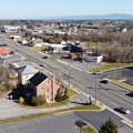
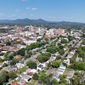
, facing west.
More at The Schumin Web:
www.schuminweb.com/2024/06/12/a-weekend-loop-trip/
Ben Schumin is a professional photographer who captures the intricacies of daily life. This image is all rights reserved. Contact me directly for licensing information.")
Ben Schumin Photography Portfolio
Ben Schumin is a professional photographer who captures the intricacies of daily life.
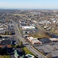
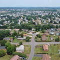
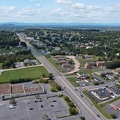
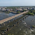
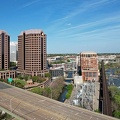
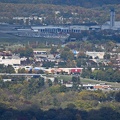
Aerial view of Thornburg, Virginia from just north of Mudd Tavern Road (VA 606), facing west.
![Roanoke from the star, January 2003 [04]](../../../../../i/upload/2024/07/14/20240714101746-72386e76-sq.jpg)
![Roanoke from the star, January 2003 [03]](../../../../../i/upload/2024/07/14/20240714101748-2add7d74-sq.jpg)
![Roanoke from the star, January 2003 [02]](../../../../../i/upload/2024/07/14/20240714101749-5603d0ac-sq.jpg)
![Roanoke from the star, January 2003 [01]](../../../../../i/upload/2024/07/14/20240714101750-8166e277-sq.jpg)

![RCA Building [01]](../../../../../i/upload/2024/07/14/20240714101955-50d1842e-sq.jpg)

![1801 North Lynn Street, viewed from Rosslyn Center parking garage [02]](../../../../../i/upload/2024/07/14/20240714102056-13050ec8-sq.jpg)
![1801 North Lynn Street, viewed from Rosslyn Center parking garage [01]](../../../../../i/upload/2024/07/14/20240714102104-1f137175-sq.jpg)


![James Monroe Building [01]](../../../../../i/upload/2024/07/14/20240714102122-d5976e29-sq.jpg)


![Rosslyn Center [01]](../../../../../i/upload/2024/07/14/20240714102228-4872f84b-sq.jpg)
![1801 North Lynn Street, viewed from close by [01]](../../../../../i/upload/2024/07/14/20240714102229-482ea670-sq.jpg)
![1801 North Lynn Street, viewed from close by [02]](../../../../../i/upload/2024/07/14/20240714102241-0c139685-sq.jpg)


![Virginia Beach from fishing pier [02]](../../../../../i/upload/2024/07/14/20240714171133-774bcfd1-sq.jpg)
![Virginia Beach from fishing pier [01]](../../../../../i/upload/2024/07/14/20240714171134-80da81d2-sq.jpg)
![Demolition of 1117 North 19th Street [02]](../../../../../i/upload/2024/07/14/20240714234453-bdd3fcad-sq.jpg)
![Demolition of 1117 North 19th Street [01]](../../../../../i/upload/2024/07/14/20240714234455-3ed3f7f8-sq.jpg)
![1801 North Lynn Street, viewed from close by [03]](../../../../../i/upload/2024/07/14/20240714234456-d23af8a7-sq.jpg)

![Allied Arts Building [01]](../../../../../i/upload/2024/07/14/20240714234612-86b3f62f-sq.jpg)
![Bank of the James building [01]](../../../../../i/upload/2024/07/14/20240714234613-7e249ac4-sq.jpg)
![Bank of the James building [02]](../../../../../i/upload/2024/07/14/20240714234616-5ade455d-sq.jpg)
![1801 North Lynn Street, viewed from close by [04]](../../../../../i/upload/2024/07/14/20240714234624-7d012224-sq.jpg)
![Stuarts Draft High School, November 2007 [01]](../../../../../i/upload/2024/07/15/20240715204739-d70c2c18-sq.jpg)
![Stuarts Draft High School, November 2007 [03]](../../../../../i/upload/2024/07/15/20240715204741-9c6e5295-sq.jpg)
![Stuarts Draft High School, November 2007 [02]](../../../../../i/upload/2024/07/15/20240715204743-48b96957-sq.jpg)
![Stuarts Draft High School, November 2007 [06]](../../../../../i/upload/2024/07/15/20240715204744-ee6bae2c-sq.jpg)
![Stuarts Draft High School, November 2007 [05]](../../../../../i/upload/2024/07/15/20240715204746-c1dbd44a-sq.jpg)
![Stuarts Draft High School, November 2007 [04]](../../../../../i/upload/2024/07/15/20240715204747-bd2ba430-sq.jpg)
![Asbestos abatement work at 1815 North Fort Myer Drive [01]](../../../../../i/upload/2024/07/15/20240715214704-e2c6e559-sq.jpg)
![Asbestos abatement work at 1815 North Fort Myer Drive [02]](../../../../../i/upload/2024/07/15/20240715214725-e36cade6-sq.jpg)


![Steeple of Arlington Temple United Methodist Church [01]](../../../../../i/upload/2024/07/15/20240715215211-d0eada91-sq.jpg)
![Steeple of Arlington Temple United Methodist Church [02]](../../../../../i/upload/2024/07/15/20240715215214-33519c6c-sq.jpg)
![1801 North Lynn Street, viewed from close by [05]](../../../../../i/upload/2024/07/15/20240715215218-05f6f453-sq.jpg)
![RCA Building [02]](../../../../../i/upload/2024/07/15/20240715215220-6ad114bc-sq.jpg)
![1815 North Fort Myer Drive and Turnberry Tower [01]](../../../../../i/upload/2024/07/15/20240715215222-a731559a-sq.jpg)
![RCA Building [03]](../../../../../i/upload/2024/07/15/20240715215224-c6ab740d-sq.jpg)
![1801 North Lynn Street, viewed from close by [06]](../../../../../i/upload/2024/07/15/20240715215226-74822916-sq.jpg)
![1815 North Fort Myer Drive and Turnberry Tower [02]](../../../../../i/upload/2024/07/15/20240715215300-820bfb90-sq.jpg)

![Long-reach excavator [15]](../../../../../i/upload/2024/07/15/20240715215304-6826c345-sq.jpg)
![Long-reach excavator [16]](../../../../../i/upload/2024/07/15/20240715215306-d68c548d-sq.jpg)
![Long-reach excavator [13]](../../../../../i/upload/2024/07/15/20240715215308-00e5afa8-sq.jpg)
![Long-reach excavator [12]](../../../../../i/upload/2024/07/15/20240715215310-077d4a0e-sq.jpg)
![Long-reach excavator [14]](../../../../../i/upload/2024/07/15/20240715215312-8db1a7d1-sq.jpg)
![Long-reach excavator [11]](../../../../../i/upload/2024/07/15/20240715215314-fe80ca02-sq.jpg)
![Long-reach excavator [10]](../../../../../i/upload/2024/07/15/20240715215316-d34b0f92-sq.jpg)
![Long-reach excavator [09]](../../../../../i/upload/2024/07/15/20240715215318-fc19a3d1-sq.jpg)
![Long-reach excavator [08]](../../../../../i/upload/2024/07/15/20240715215320-be6c6b9f-sq.jpg)
![Long-reach excavator [07]](../../../../../i/upload/2024/07/15/20240715215322-a1728cfa-sq.jpg)
![Long-reach excavator [06]](../../../../../i/upload/2024/07/15/20240715215324-03eda33b-sq.jpg)
![Man holding hose during demolition work [03]](../../../../../i/upload/2024/07/15/20240715215327-c8a23cf7-sq.jpg)
![Man holding hose during demolition work [02]](../../../../../i/upload/2024/07/15/20240715215331-dc1ec0b8-sq.jpg)
![Man holding hose during demolition work [01]](../../../../../i/upload/2024/07/15/20240715215333-91014268-sq.jpg)
![Painting at Turnberry Tower [02]](../../../../../i/upload/2024/07/15/20240715215335-5d4da0e0-sq.jpg)
![Painting at Turnberry Tower [01]](../../../../../i/upload/2024/07/15/20240715215337-2a8ce039-sq.jpg)
![Rebar and steel beams at 1815 North Fort Myer Drive [02]](../../../../../i/upload/2024/07/15/20240715215339-edfdb53d-sq.jpg)
![Rebar and steel beams at 1815 North Fort Myer Drive [01]](../../../../../i/upload/2024/07/15/20240715215341-a890a092-sq.jpg)
![RCA Building [04]](../../../../../i/upload/2024/07/16/20240716002006-ef683b4f-sq.jpg)

![Waynesboro High School [01]](../../../../../i/upload/2024/07/16/20240716003152-76fd77c2-sq.jpg)

![Richmond skyline [12]](../../../../../i/upload/2024/07/17/20240717155057-1b70ebec-sq.jpg)
![Richmond skyline [11]](../../../../../i/upload/2024/07/17/20240717155100-1121e622-sq.jpg)
![Richmond skyline [10]](../../../../../i/upload/2024/07/17/20240717155103-0850cb89-sq.jpg)
![Richmond skyline [09]](../../../../../i/upload/2024/07/17/20240717155106-9423a503-sq.jpg)
![Richmond skyline [08]](../../../../../i/upload/2024/07/17/20240717155110-33b853b1-sq.jpg)
![Richmond skyline [07]](../../../../../i/upload/2024/07/17/20240717155113-cec25ff6-sq.jpg)
![Richmond skyline [05]](../../../../../i/upload/2024/07/17/20240717155118-d2e7b5b2-sq.jpg)
![Richmond skyline [04]](../../../../../i/upload/2024/07/17/20240717155122-17d9c4b8-sq.jpg)
![Richmond skyline [03]](../../../../../i/upload/2024/07/17/20240717155130-cfb4a095-sq.jpg)
![Richmond skyline [02]](../../../../../i/upload/2024/07/17/20240717155153-fa296849-sq.jpg)
![Richmond skyline [01]](../../../../../i/upload/2024/07/17/20240717155204-034e37ba-sq.jpg)
![MeadWestvaco building [02]](../../../../../i/upload/2024/07/17/20240717155211-1f809fb5-sq.jpg)
![MeadWestvaco building [01]](../../../../../i/upload/2024/07/17/20240717155214-97c95e28-sq.jpg)
![MeadWestvaco, Federal Reserve, and Riverfront Plaza buildings [02]](../../../../../i/upload/2024/07/17/20240717155216-92d538fb-sq.jpg)
![MeadWestvaco, Federal Reserve, and Riverfront Plaza buildings [01]](../../../../../i/upload/2024/07/17/20240717155221-cdc74f24-sq.jpg)
![Vistas on the James [01]](../../../../../i/upload/2024/07/17/20240717155337-72f312c6-sq.jpg)
![Rosslyn skyline [01]](../../../../../i/upload/2024/07/17/20240717230300-9294fc8d-sq.jpg)
![Rosslyn skyline [02]](../../../../../i/upload/2024/07/17/20240717230304-8f412681-sq.jpg)
![Rosslyn skyline [03]](../../../../../i/upload/2024/07/17/20240717230307-ad97916d-sq.jpg)

![Roanoke, Virginia [01]](../../../../../i/upload/2024/07/17/20240717232316-4004d589-sq.jpg)
![Roanoke, Virginia [02]](../../../../../i/upload/2024/07/17/20240717232320-e7ffa9b7-sq.jpg)

![Parry McCluer High School [01]](../../../../../i/upload/2024/07/17/20240717232931-85783f06-sq.jpg)
![Parry McCluer High School [02]](../../../../../i/upload/2024/07/17/20240717232936-291b57ca-sq.jpg)

![M. Carl Andrews Overlook [01]](../../../../../i/upload/2024/07/17/20240717233104-18c6ba6a-sq.jpg)
![M. Carl Andrews Overlook [02]](../../../../../i/upload/2024/07/17/20240717233109-73899e0e-sq.jpg)
![M. Carl Andrews Overlook at night [01]](../../../../../i/upload/2024/07/17/20240717233141-45aa31b5-sq.jpg)
![M. Carl Andrews Overlook at night [02]](../../../../../i/upload/2024/07/17/20240717233145-af6ef7ac-sq.jpg)
![View from Dirt Farm Brewing [02]](../../../../../i/upload/2024/07/18/20240718230423-b1ac8dea-sq.jpg)
![View from Dirt Farm Brewing [01]](../../../../../i/upload/2024/07/18/20240718230427-e0fe1b23-sq.jpg)
![Adaire apartment building [01]](../../../../../i/upload/2024/07/19/20240719004159-db9a17c2-sq.jpg)
![Adaire apartment building [03]](../../../../../i/upload/2024/07/19/20240719004203-018e76a4-sq.jpg)
![Adaire apartment building [02]](../../../../../i/upload/2024/07/19/20240719004206-e8c55e7c-sq.jpg)
![Adaire apartment building [04]](../../../../../i/upload/2024/07/19/20240719004209-d4247ee1-sq.jpg)
![Adaire apartment building [06]](../../../../../i/upload/2024/07/19/20240719004212-12d083a9-sq.jpg)
![Adaire apartment building [05]](../../../../../i/upload/2024/07/19/20240719004215-fcc3dff8-sq.jpg)
![Adaire apartment building [07]](../../../../../i/upload/2024/07/19/20240719004219-5c3de320-sq.jpg)
![Icon Norfolk [05]](../../../../../i/upload/2024/07/19/20240719092601-25487cc3-sq.jpg)
![Icon Norfolk [04]](../../../../../i/upload/2024/07/19/20240719092608-70e91670-sq.jpg)
![Icon Norfolk [03]](../../../../../i/upload/2024/07/19/20240719092613-0490460c-sq.jpg)
![Icon Norfolk [02]](../../../../../i/upload/2024/07/19/20240719092618-7c8e622c-sq.jpg)
![Norfolk Waterside Marriott [02]](../../../../../i/upload/2024/07/19/20240719092701-7384cbfc-sq.jpg)
![Dominion Tower [03]](../../../../../i/upload/2024/07/19/20240719092749-46a1b10f-sq.jpg)
![Dominion Tower [02]](../../../../../i/upload/2024/07/19/20240719092753-a11599fe-sq.jpg)
![Dominion Tower [01]](../../../../../i/upload/2024/07/19/20240719092757-c7e0cd2b-sq.jpg)
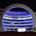
![Norfolk City Hall [03]](../../../../../i/upload/2024/07/19/20240719092802-c1cd2908-sq.jpg)
![Norfolk City Hall [02]](../../../../../i/upload/2024/07/19/20240719092807-5e8219eb-sq.jpg)
![Norfolk City Hall [01]](../../../../../i/upload/2024/07/19/20240719092812-f9620385-sq.jpg)
![Norfolk Waterside Marriott [01]](../../../../../i/upload/2024/07/19/20240719092831-696580ee-sq.jpg)
![Icon Norfolk [09]](../../../../../i/upload/2024/07/19/20240719092836-994177ff-sq.jpg)
![Icon Norfolk [01]](../../../../../i/upload/2024/07/19/20240719092841-cd101c82-sq.jpg)
![Goochland rest area, westbound [03]](../../../../../i/upload/2024/07/19/20240719093121-0aeca88a-sq.jpg)
![Goochland rest area, westbound [02]](../../../../../i/upload/2024/07/19/20240719093125-c06aafb1-sq.jpg)
![Goochland rest area, westbound [01]](../../../../../i/upload/2024/07/19/20240719093130-dbdf3bb4-sq.jpg)
![Mitre Building 4 [02]](../../../../../i/upload/2024/07/19/20240719093354-ad5266ae-sq.jpg)
![Mitre Building 4 [01]](../../../../../i/upload/2024/07/19/20240719093359-f77a5d20-sq.jpg)

![Adaire apartment building [08]](../../../../../i/upload/2024/07/19/20240719101105-3ae9d8d2-sq.jpg)
![Norfolk, Virginia at night [01]](../../../../../i/upload/2024/07/19/20240719101930-588b26d8-sq.jpg)
![Norfolk, Virginia at night [02]](../../../../../i/upload/2024/07/19/20240719101934-44552460-sq.jpg)
![Icon Norfolk [08]](../../../../../i/upload/2024/07/19/20240719102045-2b56c13a-sq.jpg)
![Icon Norfolk [07]](../../../../../i/upload/2024/07/19/20240719102050-f4a652cc-sq.jpg)
![Icon Norfolk [06]](../../../../../i/upload/2024/07/19/20240719102055-5db38dbb-sq.jpg)
![Rosslyn Center [02]](../../../../../i/upload/2024/07/19/20240719103223-e4c5c1f0-sq.jpg)
![Photographing 1750 Crystal Drive [02]](../../../../../i/upload/2024/07/19/20240719104132-158c0089-sq.jpg)
![Photographing 1750 Crystal Drive [01]](../../../../../i/upload/2024/07/19/20240719104135-a21ab6ce-sq.jpg)
![3101 Wilson Boulevard [02]](../../../../../i/upload/2024/07/19/20240719104351-2ba8b934-sq.jpg)
![3101 Wilson Boulevard [01]](../../../../../i/upload/2024/07/19/20240719104355-bee57a4b-sq.jpg)
![Washington Tower [05]](../../../../../i/upload/2024/07/19/20240719111839-552f8f2c-sq.jpg)
![Washington Tower [04]](../../../../../i/upload/2024/07/19/20240719111843-329e5cc7-sq.jpg)
![Stuarts Draft High School [01]](../../../../../i/upload/2024/07/19/20240719120518-410aadec-sq.jpg)
![Stuarts Draft High School [02]](../../../../../i/upload/2024/07/19/20240719120526-8fbd8a9f-sq.jpg)


![US 29 Business in Culpeper, Virginia [01]](../../../../../i/upload/2024/07/19/20240719155959-cf1d0444-sq.jpg)
![Stuarts Draft High School [04]](../../../../../i/upload/2024/07/19/20240719160806-68518ab0-sq.jpg)
![Stuarts Draft High School [05]](../../../../../i/upload/2024/07/19/20240719160809-c0a0f4dc-sq.jpg)
![Stuarts Draft High School [06]](../../../../../i/upload/2024/07/19/20240719160813-1d380d48-sq.jpg)
![Stuarts Draft High School [03]](../../../../../i/upload/2024/07/19/20240719160928-827af6a9-sq.jpg)
![Stuarts Draft High School [07]](../../../../../i/upload/2024/07/19/20240719160931-09dc2afc-sq.jpg)
![Richmond Avenue in Staunton, Virginia [01]](../../../../../i/upload/2024/07/19/20240719161158-ddf9fe35-sq.jpg)
![Richmond Avenue in Staunton, Virginia [02]](../../../../../i/upload/2024/07/19/20240719161203-233bb776-sq.jpg)
![Richmond Avenue in Staunton, Virginia [03]](../../../../../i/upload/2024/07/19/20240719161212-297c1b53-sq.jpg)
![Commercial area south of Interstate 81 in Harrisonburg [01]](../../../../../i/upload/2024/07/19/20240719163715-46af96f9-sq.jpg)
![Harrisonburg Crossing [01]](../../../../../i/upload/2024/07/19/20240719163753-972e0345-sq.jpg)
![Harrisonburg Crossing [02]](../../../../../i/upload/2024/07/19/20240719163758-5453496b-sq.jpg)
![Commercial area south of University Boulevard [01]](../../../../../i/upload/2024/07/19/20240719163821-e0603027-sq.jpg)
![Commercial area south of University Boulevard [02]](../../../../../i/upload/2024/07/19/20240719163825-5d4964e5-sq.jpg)
![Commercial area south of Interstate 81 in Harrisonburg [02]](../../../../../i/upload/2024/07/19/20240719163830-45dce8e7-sq.jpg)
![Waynesboro High School [06]](../../../../../i/upload/2024/07/19/20240719164001-6ba5469d-sq.jpg)
![Waynesboro High School [03]](../../../../../i/upload/2024/07/19/20240719164024-af4e2222-sq.jpg)
![Waynesboro High School [02]](../../../../../i/upload/2024/07/19/20240719164053-84203644-sq.jpg)
![Waynesboro High School [05]](../../../../../i/upload/2024/07/19/20240719164057-d9c746fc-sq.jpg)
![Waynesboro High School [04]](../../../../../i/upload/2024/07/19/20240719164123-23d6ecf4-sq.jpg)
![Churchville Volunteer Fire Department [01]](../../../../../i/upload/2024/07/19/20240719164426-c1be3535-sq.jpg)
![Churchville Volunteer Fire Department [02]](../../../../../i/upload/2024/07/19/20240719164431-2ab245f9-sq.jpg)
![Buffalo Gap High School [01]](../../../../../i/upload/2024/07/19/20240719164459-267a0d43-sq.jpg)
![Buffalo Gap High School [02]](../../../../../i/upload/2024/07/19/20240719164505-bdd29e59-sq.jpg)
![Buffalo Gap High School [03]](../../../../../i/upload/2024/07/19/20240719164509-fab8ad49-sq.jpg)
![Buffalo Gap High School [04]](../../../../../i/upload/2024/07/19/20240719164514-e0a1e82e-sq.jpg)
![Buffalo Gap High School [05]](../../../../../i/upload/2024/07/19/20240719164519-518a0909-sq.jpg)
![Buffalo Gap High School [06]](../../../../../i/upload/2024/07/19/20240719164523-e9a7db09-sq.jpg)
![West Main Street in Waynesboro, Virginia [01]](../../../../../i/upload/2024/07/19/20240719164545-b5a50599-sq.jpg)
![West Main Street in Waynesboro, Virginia [02]](../../../../../i/upload/2024/07/19/20240719164551-0b8407a8-sq.jpg)
![West Main Street in Waynesboro, Virginia [03]](../../../../../i/upload/2024/07/19/20240719164555-f7feeafe-sq.jpg)
![West Main Street in Waynesboro, Virginia [04]](../../../../../i/upload/2024/07/19/20240719164600-4379cef1-sq.jpg)
![AT&T Long Lines tower in Dumfries, Virginia [32]](../../../../../i/upload/2024/07/19/20240719165051-b8547ba1-sq.jpg)
![AT&T Long Lines tower in Dumfries, Virginia [31]](../../../../../i/upload/2024/07/19/20240719165332-7037db10-sq.jpg)
![US 29 Business in Culpeper, Virginia [02]](../../../../../i/upload/2024/07/19/20240719165937-abc06307-sq.jpg)
![US 29 North, near Hilton Heights Road [01]](../../../../../i/upload/2024/07/19/20240719171702-b12048d7-sq.jpg)
![US 29 North, near Hilton Heights Road [02]](../../../../../i/upload/2024/07/19/20240719171717-5729f873-sq.jpg)
![DoubleTree Hotel in Charlottesville, Virginia [01]](../../../../../i/upload/2024/07/19/20240719171742-a365fe34-sq.jpg)
![US 29 near Woodbrook Drive [01]](../../../../../i/upload/2024/07/19/20240719171851-a0a055c4-sq.jpg)
![US 29 near Woodbrook Drive [02]](../../../../../i/upload/2024/07/19/20240719171856-fdca65ff-sq.jpg)
![8000 Towers Crescent Drive [10]](../../../../../i/upload/2024/07/19/20240719172233-5c1581ea-sq.jpg)
![8000 Towers Crescent Drive [02]](../../../../../i/upload/2024/07/19/20240719172239-7180ac08-sq.jpg)
![8000 Towers Crescent Drive [04]](../../../../../i/upload/2024/07/19/20240719172245-de059167-sq.jpg)
![8000 Towers Crescent Drive [11]](../../../../../i/upload/2024/07/19/20240719172252-268f7911-sq.jpg)
![8000 Towers Crescent Drive [06]](../../../../../i/upload/2024/07/19/20240719172258-9a6cb9c5-sq.jpg)
![8000 Towers Crescent Drive [07]](../../../../../i/upload/2024/07/19/20240719172303-4f5bb9b7-sq.jpg)
![8000 Towers Crescent Drive [09]](../../../../../i/upload/2024/07/19/20240719172309-02335904-sq.jpg)
![8000 Towers Crescent Drive [12]](../../../../../i/upload/2024/07/19/20240719172315-275fb6ef-sq.jpg)
![8000 Towers Crescent Drive [03]](../../../../../i/upload/2024/07/19/20240719172321-c36f709f-sq.jpg)
![8000 Towers Crescent Drive [01]](../../../../../i/upload/2024/07/19/20240719172327-79d5004b-sq.jpg)
![8000 Towers Crescent Drive [05]](../../../../../i/upload/2024/07/19/20240719172332-b0849ac7-sq.jpg)
![8000 Towers Crescent Drive [08]](../../../../../i/upload/2024/07/19/20240719172337-d905a4d4-sq.jpg)
![1812 North Moore Street [01]](../../../../../i/upload/2024/07/19/20240719190152-380dd4b3-sq.jpg)
![1730 North Lynn Street [01]](../../../../../i/upload/2024/07/19/20240719190158-584fcdfe-sq.jpg)
![1730 North Lynn Street [02]](../../../../../i/upload/2024/07/19/20240719190201-10b1d6ae-sq.jpg)
![1730 North Lynn Street [03]](../../../../../i/upload/2024/07/19/20240719190205-38e45506-sq.jpg)
![1730 North Lynn Street [04]](../../../../../i/upload/2024/07/19/20240719190208-d3c50f0a-sq.jpg)
![1812 North Moore Street [02]](../../../../../i/upload/2024/07/19/20240719190212-6c5cc98a-sq.jpg)
![1812 North Moore Street [03]](../../../../../i/upload/2024/07/19/20240719190215-f82de9f1-sq.jpg)
![1730 North Lynn Street [05]](../../../../../i/upload/2024/07/19/20240719190218-88a9a181-sq.jpg)
![Truist sign at 150 West Main Street [01]](../../../../../i/upload/2024/07/19/20240719202626-975c1572-sq.jpg)
![River Park Tower Apartments [01]](../../../../../i/upload/2024/07/19/20240719202723-ab15e198-sq.jpg)
![Truist sign at 150 West Main Street [02]](../../../../../i/upload/2024/07/19/20240719202805-8a1bb6a6-sq.jpg)
![2 Eaton Street [02]](../../../../../i/upload/2024/07/19/20240719210401-8364ea14-sq.jpg)
![Armada Hoffler Tower [01]](../../../../../i/upload/2024/07/19/20240719210438-61d75799-sq.jpg)
![Armada Hoffler Tower [02]](../../../../../i/upload/2024/07/19/20240719210443-83c3ff0c-sq.jpg)
![2 Eaton Street [01]](../../../../../i/upload/2024/07/19/20240719210610-dccc3ada-sq.jpg)
![2 Eaton Street [03]](../../../../../i/upload/2024/07/19/20240719210625-7dcc5404-sq.jpg)
![Hotels along the Virginia Beach boardwalk [01]](../../../../../i/upload/2024/07/19/20240719210656-3ccf50bc-sq.jpg)
![Virginia Beach from offshore [02]](../../../../../i/upload/2024/07/19/20240719210816-e04b782c-sq.jpg)
![Hotels along the Virginia Beach boardwalk [03]](../../../../../i/upload/2024/07/19/20240719210859-0b088efc-sq.jpg)
![Aerial view of Virginia Beach Fishing Pier [02]](../../../../../i/upload/2024/07/19/20240719210909-236bbcde-sq.jpg)
![Hotels along the Virginia Beach boardwalk [02]](../../../../../i/upload/2024/07/19/20240719210949-34df1cbf-sq.jpg)
![Icon Norfolk [10]](../../../../../i/upload/2024/07/19/20240719211004-bb5718bc-sq.jpg)
![Aerial view of Virginia Beach Fishing Pier [01]](../../../../../i/upload/2024/07/19/20240719211017-dc20bf92-sq.jpg)
![Interstate 95 in Woodbridge, Virginia [02]](../../../../../i/upload/2024/07/19/20240719212229-ff1f3c31-sq.jpg)


![Zane Showker Hall [01]](../../../../../i/upload/2024/07/20/20240720020744-ff6fa84c-sq.jpg)
![Zane Showker Hall [02]](../../../../../i/upload/2024/07/20/20240720020805-e734a547-sq.jpg)
![Zane Showker Hall [03]](../../../../../i/upload/2024/07/20/20240720020846-8059cf0d-sq.jpg)
![Scott Hill Retirement Community [01]](../../../../../i/upload/2024/07/20/20240720022014-a14a5661-sq.jpg)
![Scott Hill Retirement Community [02]](../../../../../i/upload/2024/07/20/20240720022019-7ad47a06-sq.jpg)
![West Broad Street at Staples Mill Road [01]](../../../../../i/upload/2024/07/20/20240720091824-c8526d69-sq.jpg)
![Former Ramada Inn in Petersburg, Virginia [01]](../../../../../i/upload/2024/07/20/20240720091901-cd8021e0-sq.jpg)
![Former Ramada Inn in Petersburg, Virginia [02]](../../../../../i/upload/2024/07/20/20240720091950-5949b96a-sq.jpg)
![West Broad Street at Staples Mill Road [02]](../../../../../i/upload/2024/07/20/20240720092012-1df12de7-sq.jpg)
![Holiday Inn Express on Staples Mill Road [01]](../../../../../i/upload/2024/07/20/20240720092024-05d8fbae-sq.jpg)
![Former Ramada Inn in Petersburg, Virginia [03]](../../../../../i/upload/2024/07/20/20240720092049-e9ada01d-sq.jpg)
![Former Ramada Inn in Petersburg, Virginia [04]](../../../../../i/upload/2024/07/20/20240720092129-fe9911a4-sq.jpg)
![Holiday Inn Express on Staples Mill Road [02]](../../../../../i/upload/2024/07/20/20240720092149-d50c6216-sq.jpg)
![Former Ramada Inn in Petersburg, Virginia [05]](../../../../../i/upload/2024/07/20/20240720092215-0b5a8d19-sq.jpg)
![Former Ramada Inn in Petersburg, Virginia [06]](../../../../../i/upload/2024/07/20/20240720092248-8838faff-sq.jpg)
![Former Ramada Inn in Petersburg, Virginia [07]](../../../../../i/upload/2024/07/20/20240720092315-d7501f18-sq.jpg)
![Former Ramada Inn in Petersburg, Virginia [08]](../../../../../i/upload/2024/07/20/20240720092345-1c0d8ebb-sq.jpg)
![Former Ramada Inn in Petersburg, Virginia [09]](../../../../../i/upload/2024/07/20/20240720092424-668ad8c1-sq.jpg)
![Former Ramada Inn in Petersburg, Virginia [10]](../../../../../i/upload/2024/07/20/20240720092439-742c2361-sq.jpg)
![Former Ramada Inn in Petersburg, Virginia [12]](../../../../../i/upload/2024/07/20/20240720092527-90b48896-sq.jpg)
![Former Ramada Inn in Petersburg, Virginia [13]](../../../../../i/upload/2024/07/20/20240720092543-bfc9a8d5-sq.jpg)
![Former Ramada Inn in Petersburg, Virginia [14]](../../../../../i/upload/2024/07/20/20240720092556-361dc065-sq.jpg)
![Former Ramada Inn in Petersburg, Virginia [15]](../../../../../i/upload/2024/07/20/20240720092606-e740262a-sq.jpg)
![Former Ramada Inn in Petersburg, Virginia [16]](../../../../../i/upload/2024/07/20/20240720092611-36c540de-sq.jpg)
![Former Ramada Inn in Petersburg, Virginia [17]](../../../../../i/upload/2024/07/20/20240720092616-3895502e-sq.jpg)
![Pyramid at Hollywood Cemetery [05]](../../../../../i/upload/2024/07/20/20240720092632-7942cc5a-sq.jpg)
![Federal Reserve Bank building [03]](../../../../../i/upload/2024/07/20/20240720092657-131d1c93-sq.jpg)
![Federal Reserve Bank building [05]](../../../../../i/upload/2024/07/20/20240720092702-4d325559-sq.jpg)
![Skyline of Richmond, Virginia from over the James River [05]](../../../../../i/upload/2024/07/20/20240720092707-f5afb553-sq.jpg)
![CoStar Richmond office [02]](../../../../../i/upload/2024/07/20/20240720092713-e39a0b00-sq.jpg)
![Church Hill neighborhood [01]](../../../../../i/upload/2024/07/20/20240720092724-5ad8079d-sq.jpg)
![Church Hill neighborhood [02]](../../../../../i/upload/2024/07/20/20240720092729-c1c95489-sq.jpg)
![James Monroe Building [03]](../../../../../i/upload/2024/07/20/20240720092752-9ab27160-sq.jpg)
![James Monroe Building [05]](../../../../../i/upload/2024/07/20/20240720092757-53c7f8ab-sq.jpg)
![Interstate 95 through downtown Richmond [04]](../../../../../i/upload/2024/07/20/20240720092805-0fe0379c-sq.jpg)
![Pyramid at Hollywood Cemetery [04]](../../../../../i/upload/2024/07/20/20240720092820-4c879a86-sq.jpg)
![CoStar Richmond office [01]](../../../../../i/upload/2024/07/20/20240720092854-506a1cc9-sq.jpg)
![James Monroe Building [04]](../../../../../i/upload/2024/07/20/20240720092941-0cff135f-sq.jpg)
![Clock tower on Richmond Main Street Station [01]](../../../../../i/upload/2024/07/20/20240720092945-196e9f26-sq.jpg)
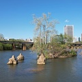
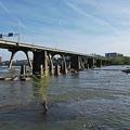
![Remains of Richmond and Petersburg Railroad Bridge [01]](../../../../../i/upload/2024/07/20/20240720093002-8c94d1f5-sq.jpg)
![Remains of Richmond and Petersburg Railroad Bridge [02]](../../../../../i/upload/2024/07/20/20240720093007-71c83e39-sq.jpg)
![Rapids on the James River [01]](../../../../../i/upload/2024/07/20/20240720093011-a767724e-sq.jpg)
![Interstate 95 through downtown Richmond [02]](../../../../../i/upload/2024/07/20/20240720093017-3f2bee68-sq.jpg)
![Richmond skyline from the James River [02]](../../../../../i/upload/2024/07/20/20240720093043-34fedc56-sq.jpg)
![Richmond skyline from the James River [01]](../../../../../i/upload/2024/07/20/20240720093109-1fb6414b-sq.jpg)
![Rapids on the James River [02]](../../../../../i/upload/2024/07/20/20240720093135-219eaaa3-sq.jpg)

![Skyline of Richmond, Virginia from over the James River [06]](../../../../../i/upload/2024/07/20/20240720093145-04645085-sq.jpg)
![Clock tower on Richmond Main Street Station [02]](../../../../../i/upload/2024/07/20/20240720093156-e35dc707-sq.jpg)
![Federal Reserve and Riverfront Plaza [02]](../../../../../i/upload/2024/07/20/20240720093206-5733a975-sq.jpg)
![Interstate 95 through downtown Richmond [03]](../../../../../i/upload/2024/07/20/20240720093212-fa09ec51-sq.jpg)
![Skyline of Richmond, Virginia from over the James River [01]](../../../../../i/upload/2024/07/20/20240720093217-566c68d2-sq.jpg)
![Skyline of Richmond, Virginia from over the James River [04]](../../../../../i/upload/2024/07/20/20240720093223-e807486f-sq.jpg)
![Skyline of Richmond, Virginia from over the James River [03]](../../../../../i/upload/2024/07/20/20240720093228-9fe867a4-sq.jpg)
![CoStar Richmond office [03]](../../../../../i/upload/2024/07/20/20240720093234-91d038ef-sq.jpg)
![CoStar Richmond office [04]](../../../../../i/upload/2024/07/20/20240720093239-a22e968a-sq.jpg)
![CoStar Richmond office [05]](../../../../../i/upload/2024/07/20/20240720093244-45f5b31e-sq.jpg)
![Federal Reserve Bank building [04]](../../../../../i/upload/2024/07/20/20240720093303-e8935b84-sq.jpg)
![James Monroe Building [02]](../../../../../i/upload/2024/07/20/20240720093314-e2c8ccea-sq.jpg)
![Interstate 95 through downtown Richmond [01]](../../../../../i/upload/2024/07/20/20240720093319-14a1e75d-sq.jpg)
![Skyline of Richmond, Virginia from over the James River [02]](../../../../../i/upload/2024/07/20/20240720093329-b8ae5a03-sq.jpg)
![Farm on the Virginia-West Virginia border [01]](../../../../../i/upload/2024/07/20/20240720094156-2b1215da-sq.jpg)
![Sign for B&R Grocery [02]](../../../../../i/upload/2024/07/20/20240720094727-ec616e81-sq.jpg)
![Sign for B&R Grocery [01]](../../../../../i/upload/2024/07/20/20240720094732-3f67b536-sq.jpg)
![Former Ramada Inn in Petersburg, Virginia [11]](../../../../../i/upload/2024/07/20/20240720100214-7339a820-sq.jpg)
![Elm Avenue interchange [02]](../../../../../i/upload/2024/07/20/20240720121652-6267da79-sq.jpg)
![Aerial view of Roanoke, Virginia [01]](../../../../../i/upload/2024/07/20/20240720121757-bb58476c-sq.jpg)
![Aerial view of Roanoke, Virginia [02]](../../../../../i/upload/2024/07/20/20240720121808-dccb83a0-sq.jpg)
![Aerial view of Roanoke, Virginia [03]](../../../../../i/upload/2024/07/20/20240720121837-3c6bbb13-sq.jpg)
![Aerial view of Roanoke, Virginia [04]](../../../../../i/upload/2024/07/20/20240720121854-34748718-sq.jpg)
![Aerial view of Roanoke, Virginia [05]](../../../../../i/upload/2024/07/20/20240720121906-5f802cee-sq.jpg)
![Aerial view of Roanoke, Virginia [06]](../../../../../i/upload/2024/07/20/20240720121917-3d4a6311-sq.jpg)
![View from the Roanoke Star, October 2022 [01]](../../../../../i/upload/2024/07/20/20240720121935-9c3d81cd-sq.jpg)
![View from the Roanoke Star, October 2022 [02]](../../../../../i/upload/2024/07/20/20240720121946-ef64a8e5-sq.jpg)
![View from the Roanoke Star, October 2022 [03]](../../../../../i/upload/2024/07/20/20240720121951-aad25312-sq.jpg)
![View from the Roanoke Star, October 2022 [04]](../../../../../i/upload/2024/07/20/20240720121957-f438f2a3-sq.jpg)
![Elm Avenue interchange [01]](../../../../../i/upload/2024/07/20/20240720122015-70544823-sq.jpg)
![Reston Town Center station entrance pylon [02]](../../../../../i/upload/2024/07/20/20240720123403-c78e011e-sq.jpg)
![George Washington Masonic National Memorial in early evening [03]](../../../../../i/upload/2024/07/20/20240720144312-e3cd292f-sq.jpg)
![George Washington Masonic National Memorial in early evening [02]](../../../../../i/upload/2024/07/20/20240720144323-049b85fb-sq.jpg)
![George Washington Masonic National Memorial in early evening [07]](../../../../../i/upload/2024/07/20/20240720144357-af722cc0-sq.jpg)
![George Washington Masonic National Memorial in early evening [04]](../../../../../i/upload/2024/07/20/20240720144403-1e834e0d-sq.jpg)
![George Washington Masonic National Memorial in early evening [01]](../../../../../i/upload/2024/07/20/20240720144408-40f99ed3-sq.jpg)
![George Washington Masonic National Memorial in early evening [05]](../../../../../i/upload/2024/07/20/20240720144414-2c154936-sq.jpg)
![George Washington Masonic National Memorial in early evening [10]](../../../../../i/upload/2024/07/20/20240720144451-f77b543e-sq.jpg)
![George Washington Masonic National Memorial in early evening [08]](../../../../../i/upload/2024/07/20/20240720144457-2d4233a6-sq.jpg)
![George Washington Masonic National Memorial in early evening [06]](../../../../../i/upload/2024/07/20/20240720144503-d7277ff1-sq.jpg)
![George Washington Masonic National Memorial in early evening [11]](../../../../../i/upload/2024/07/20/20240720144541-09f0d549-sq.jpg)
![George Washington Masonic National Memorial in early evening [09]](../../../../../i/upload/2024/07/20/20240720144547-95ade40f-sq.jpg)

![Vistas on the James [02]](../../../../../i/upload/2024/07/20/20240720145223-218dc7fa-sq.jpg)
![T. Tyler Potterfield Memorial Bridge [01]](../../../../../i/upload/2024/07/20/20240720145345-a099e1a0-sq.jpg)
![Riverfront Plaza [05]](../../../../../i/upload/2024/07/20/20240720145511-b90e6376-sq.jpg)
![CoStar Richmond office [06]](../../../../../i/upload/2024/07/20/20240720145520-4232126b-sq.jpg)
![T. Tyler Potterfield Memorial Bridge [02]](../../../../../i/upload/2024/07/20/20240720145530-274bdebb-sq.jpg)
![Skyline of Richmond from T. Tyler Potterfield Memorial Bridge [01]](../../../../../i/upload/2024/07/20/20240720145540-4b66f9db-sq.jpg)
![CoStar Richmond office [07]](../../../../../i/upload/2024/07/20/20240720145545-adafb656-sq.jpg)
![CoStar Richmond office [08]](../../../../../i/upload/2024/07/20/20240720145601-423a28f4-sq.jpg)
![Skyline of Richmond from T. Tyler Potterfield Memorial Bridge [02]](../../../../../i/upload/2024/07/20/20240720145607-9ab4c864-sq.jpg)
![Federal Reserve Bank building [06]](../../../../../i/upload/2024/07/20/20240720145622-21861918-sq.jpg)
![Skyline of Richmond from T. Tyler Potterfield Memorial Bridge [03]](../../../../../i/upload/2024/07/20/20240720145627-fae67f7d-sq.jpg)
![Skyline of Richmond from T. Tyler Potterfield Memorial Bridge [04]](../../../../../i/upload/2024/07/20/20240720145642-31bb29f7-sq.jpg)
![Federal Reserve Bank building [07]](../../../../../i/upload/2024/07/20/20240720145647-a1f8393d-sq.jpg)
![Federal Reserve Bank building [08]](../../../../../i/upload/2024/07/20/20240720145656-bec1755a-sq.jpg)

![Beverley Manor Elementary School [01]](../../../../../i/upload/2024/11/25/20241125094518-95cad8f5-sq.jpg)
![Beverley Manor Elementary School [02]](../../../../../i/upload/2024/11/25/20241125094530-c2499bd9-sq.jpg)
![Fort Defiance High School [01]](../../../../../i/upload/2024/11/27/20241127091708-7ebe92dc-sq.jpg)
![Fort Defiance High School [02]](../../../../../i/upload/2024/11/27/20241127091712-f1f895f7-sq.jpg)
![Fort Defiance High School [03]](../../../../../i/upload/2024/11/27/20241127091716-b7c43d41-sq.jpg)
![Fort Defiance High School [04]](../../../../../i/upload/2024/11/27/20241127091720-b5fbcdd5-sq.jpg)
![Fort Defiance High School [05]](../../../../../i/upload/2024/11/27/20241127091724-80606f8d-sq.jpg)
![Fort Defiance High School [06]](../../../../../i/upload/2024/11/27/20241127091728-68d10bb9-sq.jpg)
![Fort Defiance High School [08]](../../../../../i/upload/2024/11/27/20241127091732-be0eca8c-sq.jpg)
![Fort Defiance High School [09]](../../../../../i/upload/2024/11/27/20241127091736-ce2c9a00-sq.jpg)
![Fort Defiance High School [10]](../../../../../i/upload/2024/11/27/20241127091740-6e8c728d-sq.jpg)
![Fort Defiance High School [12]](../../../../../i/upload/2024/11/27/20241127091744-54518ea7-sq.jpg)
![Fort Defiance High School [13]](../../../../../i/upload/2024/11/27/20241127091820-d31ca16d-sq.jpg)
![Fort Defiance High School [14]](../../../../../i/upload/2024/11/27/20241127091905-2495f6fd-sq.jpg)
![Fort Defiance High School [16]](../../../../../i/upload/2024/11/27/20241127091949-55ad577b-sq.jpg)
![Fort Defiance High School [07]](../../../../../i/upload/2024/11/27/20241127092725-1ff22f96-sq.jpg)
![Fort Defiance High School [11]](../../../../../i/upload/2024/11/27/20241127092736-1e6e0358-sq.jpg)
![Fort Defiance High School [15]](../../../../../i/upload/2024/11/27/20241127092756-88fa6c0c-sq.jpg)
![Wilson Memorial High School [01]](../../../../../i/upload/2024/11/28/20241128132944-b26d461f-sq.jpg)
![Wilson Memorial High School [02]](../../../../../i/upload/2024/11/28/20241128132949-0e20e7c2-sq.jpg)
![Wilson Memorial High School [03]](../../../../../i/upload/2024/11/28/20241128132953-506e458b-sq.jpg)
![Wilson Memorial High School [04]](../../../../../i/upload/2024/11/28/20241128132957-03a4b369-sq.jpg)
![Wilson Memorial High School [05]](../../../../../i/upload/2024/11/28/20241128133001-dd5a876a-sq.jpg)
![Wilson Memorial High School [06]](../../../../../i/upload/2024/11/28/20241128133005-70772020-sq.jpg)
![Wilson Memorial High School [07]](../../../../../i/upload/2024/11/28/20241128133009-5ad4cf25-sq.jpg)
![Riverheads High School [01]](../../../../../i/upload/2024/11/28/20241128234210-f98993d4-sq.jpg)
![Riverheads High School [02]](../../../../../i/upload/2024/11/28/20241128234228-4c25b70c-sq.jpg)
![Riverheads High School [03]](../../../../../i/upload/2024/11/28/20241128234243-f9e0eb91-sq.jpg)
![Riverheads High School [04]](../../../../../i/upload/2024/11/28/20241128234325-619d414c-sq.jpg)
![Riverheads High School [05]](../../../../../i/upload/2024/11/28/20241128234415-0312a92c-sq.jpg)
![Riverheads High School [06]](../../../../../i/upload/2024/11/28/20241128234509-7a78f401-sq.jpg)
![Riverheads High School [07]](../../../../../i/upload/2024/11/28/20241128234645-fb85ca2b-sq.jpg)
![Riverheads High School [08]](../../../../../i/upload/2024/11/28/20241128234810-2bcf854e-sq.jpg)
![Riverheads High School [09]](../../../../../i/upload/2024/11/28/20241128234835-01536756-sq.jpg)
![Riverheads High School [10]](../../../../../i/upload/2024/11/28/20241128234922-4572527a-sq.jpg)
![Riverheads High School [11]](../../../../../i/upload/2024/11/28/20241128235104-1b760647-sq.jpg)
![Riverheads High School [12]](../../../../../i/upload/2024/11/28/20241128235124-6c00f637-sq.jpg)
![Riverheads High School [13]](../../../../../i/upload/2024/11/28/20241128235208-34d335d7-sq.jpg)
![Riverheads High School [14]](../../../../../i/upload/2024/11/28/20241128235305-d6e62632-sq.jpg)
![Stuarts Draft High School [08]](../../../../../i/upload/2024/11/29/20241129014552-5ec438cd-sq.jpg)
![Stuarts Draft High School [09]](../../../../../i/upload/2024/11/29/20241129014557-4586a58e-sq.jpg)
![Stuarts Draft High School [10]](../../../../../i/upload/2024/11/29/20241129014600-7ef70999-sq.jpg)
![Stuarts Draft High School [11]](../../../../../i/upload/2024/11/29/20241129014604-7d3713c8-sq.jpg)
![Stuarts Draft High School [12]](../../../../../i/upload/2024/11/29/20241129014609-c7e3ec00-sq.jpg)
![Stuarts Draft High School [13]](../../../../../i/upload/2024/11/29/20241129014612-486643c5-sq.jpg)
![Stuarts Draft High School [14]](../../../../../i/upload/2024/11/29/20241129014617-56bd96f1-sq.jpg)
![Stuarts Draft High School [15]](../../../../../i/upload/2024/11/29/20241129014620-10f6b706-sq.jpg)
![Stuarts Draft High School [16]](../../../../../i/upload/2024/11/29/20241129014624-17b8c765-sq.jpg)

![Aerial view of Monterey, Virginia [01]](../../../../../i/upload/2025/01/02/20250102005918-685606f9-sq.jpg)
![Aerial view of Monterey, Virginia [02]](../../../../../i/upload/2025/01/02/20250102005923-7f7b9b83-sq.jpg)
![Aerial view of Monterey, Virginia [03]](../../../../../i/upload/2025/01/02/20250102005929-2e84a9d0-sq.jpg)
![Aerial view of Monterey, Virginia [04]](../../../../../i/upload/2025/01/02/20250102005937-281fae65-sq.jpg)
![Aerial view of Monterey, Virginia [05]](../../../../../i/upload/2025/01/02/20250102005946-79efaa38-sq.jpg)
![Aerial view of Monterey, Virginia [06]](../../../../../i/upload/2025/01/02/20250102005956-29786301-sq.jpg)

![Buffalo Gap Middle and High Schools [01]](../../../../../i/upload/2025/01/03/20250103202026-5cdc496f-sq.jpg)
![Buffalo Gap Middle and High Schools [02]](../../../../../i/upload/2025/01/03/20250103202032-55e71413-sq.jpg)
![Buffalo Gap Middle and High Schools [03]](../../../../../i/upload/2025/01/03/20250103202038-0ede0383-sq.jpg)
![Buffalo Gap Middle and High Schools [04]](../../../../../i/upload/2025/01/03/20250103202044-b8863daf-sq.jpg)
![Buffalo Gap Middle and High Schools [05]](../../../../../i/upload/2025/01/03/20250103202050-4b55d57a-sq.jpg)
![Buffalo Gap Middle and High Schools [06]](../../../../../i/upload/2025/01/03/20250103202056-3a028545-sq.jpg)
![Buffalo Gap Middle and High Schools [07]](../../../../../i/upload/2025/01/03/20250103202103-2963fcc1-sq.jpg)
![Buffalo Gap Middle and High Schools [08]](../../../../../i/upload/2025/01/03/20250103202111-0d42bedb-sq.jpg)
![Buffalo Gap Middle and High Schools [09]](../../../../../i/upload/2025/01/03/20250103202117-3e1c51f7-sq.jpg)
![Buffalo Gap Middle and High Schools [10]](../../../../../i/upload/2025/01/03/20250103202123-a70709f6-sq.jpg)
![River Park Tower Apartments [02]](../../../../../i/upload/2025/02/18/20250218102157-99fbbb4b-sq.jpg)

![Monitor-Merrimac Memorial Bridge-Tunnel [01]](../../../../../i/upload/2025/02/18/20250218235632-5aef878d-sq.jpg)
![Monitor-Merrimac Memorial Bridge-Tunnel [02]](../../../../../i/upload/2025/02/18/20250218235637-581fbcca-sq.jpg)
![Monitor-Merrimac Memorial Bridge-Tunnel [03]](../../../../../i/upload/2025/02/18/20250218235642-270961d8-sq.jpg)
![Monitor-Merrimac Memorial Bridge-Tunnel [04]](../../../../../i/upload/2025/02/18/20250218235648-fca8ade5-sq.jpg)
![Monitor-Merrimac Memorial Bridge-Tunnel [05]](../../../../../i/upload/2025/02/18/20250218235653-19c3fdef-sq.jpg)
![Monitor-Merrimac Memorial Bridge-Tunnel [06]](../../../../../i/upload/2025/02/18/20250218235658-5bb810e5-sq.jpg)
![Monitor-Merrimac Memorial Bridge-Tunnel [07]](../../../../../i/upload/2025/02/18/20250218235704-55afa576-sq.jpg)
![Monitor-Merrimac Memorial Bridge-Tunnel [08]](../../../../../i/upload/2025/02/18/20250218235709-560750da-sq.jpg)
![Monitor-Merrimac Memorial Bridge-Tunnel [09]](../../../../../i/upload/2025/02/18/20250218235714-45502513-sq.jpg)
![Monitor-Merrimac Memorial Bridge-Tunnel [10]](../../../../../i/upload/2025/02/18/20250218235719-11c76977-sq.jpg)
![Monitor-Merrimac Memorial Bridge-Tunnel [11]](../../../../../i/upload/2025/02/18/20250218235725-ef9b2fb8-sq.jpg)
![Monitor-Merrimac Memorial Bridge-Tunnel [12]](../../../../../i/upload/2025/02/18/20250218235731-5172cc89-sq.jpg)
![Dollar Tree Corporate Office [01]](../../../../../i/upload/2025/02/19/20250219212847-eeb88fc3-sq.jpg)
![Dollar Tree Corporate Office [02]](../../../../../i/upload/2025/02/19/20250219212859-e02df95f-sq.jpg)
![Dollar Tree Corporate Office [03]](../../../../../i/upload/2025/02/19/20250219213004-a8f5a593-sq.jpg)
![Dollar Tree Corporate Office [04]](../../../../../i/upload/2025/02/19/20250219213027-6b87d89c-sq.jpg)
![Dollar Tree Corporate Office [05]](../../../../../i/upload/2025/02/19/20250219213153-7311378c-sq.jpg)

![Aerial view of downtown Lynchburg [01]](../../../../../i/upload/2025/02/28/20250228215207-816965cd-sq.jpg)
![Aerial view of downtown Lynchburg [02]](../../../../../i/upload/2025/02/28/20250228215213-a5dd2779-sq.jpg)
![Aerial view of downtown Lynchburg [03]](../../../../../i/upload/2025/02/28/20250228215218-ffa5d68d-sq.jpg)
![Bank of the James building [03]](../../../../../i/upload/2025/02/28/20250228215224-5dade886-sq.jpg)
![Allied Arts Building [02]](../../../../../i/upload/2025/02/28/20250228215231-6b669c5e-sq.jpg)
![Allied Arts Building [03]](../../../../../i/upload/2025/02/28/20250228215236-7f0b55fb-sq.jpg)
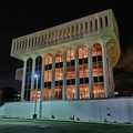
![Poff Federal Building [01]](../../../../../i/upload/2025/03/02/20250302134711-675ab6c7-sq.jpg)
![Poff Federal Building [02]](../../../../../i/upload/2025/03/02/20250302134720-6d41525c-sq.jpg)
![Hampton Inn in downtown Roanoke [01]](../../../../../i/upload/2025/03/02/20250302134739-3fb23c16-sq.jpg)
![Hampton Inn in downtown Roanoke [02]](../../../../../i/upload/2025/03/02/20250302134750-3bedaef7-sq.jpg)
![Carilion Administrative Services Building [01]](../../../../../i/upload/2025/03/02/20250302134801-6477a7f8-sq.jpg)
![Carilion Administrative Services Building [02]](../../../../../i/upload/2025/03/02/20250302134813-241abfec-sq.jpg)
![Wells Fargo Tower [01]](../../../../../i/upload/2025/03/02/20250302134825-e3412be2-sq.jpg)
![Wells Fargo Tower [02]](../../../../../i/upload/2025/03/02/20250302134831-92a15775-sq.jpg)

![Elm Avenue interchange [03]](../../../../../i/upload/2025/03/03/20250303170720-a5bd3de6-sq.jpg)
![Elm Avenue interchange [04]](../../../../../i/upload/2025/03/03/20250303170729-c4512aea-sq.jpg)
![Wells Fargo Tower [03]](../../../../../i/upload/2025/03/03/20250303170735-d26842f9-sq.jpg)
![Wells Fargo Tower [04]](../../../../../i/upload/2025/03/03/20250303170817-77f8c38e-sq.jpg)
![Wells Fargo Tower [05]](../../../../../i/upload/2025/03/03/20250303170920-70ca29f8-sq.jpg)
![Wells Fargo Tower [06]](../../../../../i/upload/2025/03/03/20250303171038-5db0edf1-sq.jpg)
Information
- Author
- Ben Schumin
- Copyright
- All Rights Reserved
- Created on
- Saturday 1 June 2024
- Dimensions
- 8064*4536
EXIF Metadata
DJI FC8282
f/170/100
1/2000
200
0/10
0
- DateTimeOriginal
- 2024:06:01 18:40:03
- DateTimeDigitized
- 2024:06:01 18:40:03
- Make
- DJI
- Model
- FC8282
- ExposureProgram
- 2
- FocalLengthIn35mmFilm
- 24
- FNumber
- 170/100
- ExposureTime
- 1/2000
- ISOSpeedRatings
- 200
- Flash
- 0
- WhiteBalance
- 0
- XResolution
- 720000/10000
- YResolution
- 720000/10000
- ImageWidth
- 8064
- ImageLength
- 4536
- Orientation
- 1
- SamplesPerPixel
- 3
- ExposureBiasValue
- 0/10
- MaxApertureValue
- 153/100
- MeteringMode
- 1
- LightSource
- 10
Powered by Piwigo