
Ben Schumin Photography Portfolio
Ben Schumin is a professional photographer who captures the intricacies of daily life.
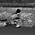
Burnt Mills Dam, on the Northwest Branch of the Anacostia River, along US 29 in Silver Spring, Maryland between Four Corners and White Oak.
![Old Town Alexandria [01]](../../../../../i/upload/2024/07/14/20240714102020-cc1e9d11-sq.jpg)
![Hains Point [01]](../../../../../i/upload/2024/07/14/20240714102048-d277efa0-sq.jpg)
![Old Town Alexandria [03]](../../../../../i/upload/2024/07/14/20240714102049-bca34b25-sq.jpg)
![Old Town Alexandria [02]](../../../../../i/upload/2024/07/14/20240714102050-6aa56370-sq.jpg)
![Hains Point [02]](../../../../../i/upload/2024/07/14/20240714102053-0461ccd3-sq.jpg)


![Pedestrian bridge to Belle Isle [02]](../../../../../i/upload/2024/07/14/20240714102108-7a6e89c3-sq.jpg)

![Archway and gate at Reynolds Wrap building [01]](../../../../../i/upload/2024/07/14/20240714102111-0129a9a4-sq.jpg)

![Pedestrian bridge to Belle Isle [01]](../../../../../i/upload/2024/07/14/20240714102117-7b4f23d3-sq.jpg)


![Former R.J. Reynolds building [01]](../../../../../i/upload/2024/07/14/20240714102123-f750d86b-sq.jpg)
![Former R.J. Reynolds building [02]](../../../../../i/upload/2024/07/14/20240714102124-8df4875a-sq.jpg)

![Road over Gathright Dam [02]](../../../../../i/upload/2024/07/14/20240714102132-396c8a23-sq.jpg)


![Road over Gathright Dam [01]](../../../../../i/upload/2024/07/14/20240714102138-0aa862c7-sq.jpg)

![No parking sign on Gathright Dam [01]](../../../../../i/upload/2024/07/14/20240714102141-459f947d-sq.jpg)
![Kia Soul in Shockoe Bottom parking lot [03]](../../../../../i/upload/2024/07/17/20240717155001-43a19547-sq.jpg)
![Kia Soul in Shockoe Bottom parking lot [02]](../../../../../i/upload/2024/07/17/20240717155003-dcef5bbc-sq.jpg)
![Kia Soul in Shockoe Bottom parking lot [01]](../../../../../i/upload/2024/07/17/20240717155005-a2d38bbe-sq.jpg)
![Ramp to Downtown Expressway [02]](../../../../../i/upload/2024/07/17/20240717155008-eff88bf6-sq.jpg)
![Railroad bridge [05]](../../../../../i/upload/2024/07/17/20240717155011-55bc146d-sq.jpg)
![Railroad bridge [04]](../../../../../i/upload/2024/07/17/20240717155013-784d7c58-sq.jpg)
![Ramp to Downtown Expressway [01]](../../../../../i/upload/2024/07/17/20240717155016-33eaba18-sq.jpg)
![Richmond floodwall opening for Canal [03]](../../../../../i/upload/2024/07/17/20240717155019-c4b734ef-sq.jpg)
![Canal Walk through Shockoe Bottom [05]](../../../../../i/upload/2024/07/17/20240717155021-9a708136-sq.jpg)
![Canal Walk through Shockoe Bottom [04]](../../../../../i/upload/2024/07/17/20240717155024-693f8160-sq.jpg)

![Curve in the Canal [02]](../../../../../i/upload/2024/07/17/20240717155029-38d7ccbe-sq.jpg)
![Curve in the Canal [01]](../../../../../i/upload/2024/07/17/20240717155032-9c996cde-sq.jpg)

![The Italianate [06]](../../../../../i/upload/2024/07/17/20240717155036-84d4da7f-sq.jpg)
![The Italianate [05]](../../../../../i/upload/2024/07/17/20240717155038-4d2f4d7b-sq.jpg)
![The Italianate [04]](../../../../../i/upload/2024/07/17/20240717155040-20d20eb5-sq.jpg)
![Riverfront Plaza [04]](../../../../../i/upload/2024/07/17/20240717155043-f1f22937-sq.jpg)

![Federal Reserve Bank building [02]](../../../../../i/upload/2024/07/17/20240717155047-038586d8-sq.jpg)
![Riverfront Plaza west tower [02]](../../../../../i/upload/2024/07/17/20240717155050-78f1d3cf-sq.jpg)

![Shoes hanging from bridge cable [02]](../../../../../i/upload/2024/07/17/20240717155055-e9aa5fd7-sq.jpg)
![Richmond skyline [12]](../../../../../i/upload/2024/07/17/20240717155057-1b70ebec-sq.jpg)
![Richmond skyline [11]](../../../../../i/upload/2024/07/17/20240717155100-1121e622-sq.jpg)
![Richmond skyline [10]](../../../../../i/upload/2024/07/17/20240717155103-0850cb89-sq.jpg)
![Richmond skyline [09]](../../../../../i/upload/2024/07/17/20240717155106-9423a503-sq.jpg)
![Richmond skyline [08]](../../../../../i/upload/2024/07/17/20240717155110-33b853b1-sq.jpg)
![Richmond skyline [07]](../../../../../i/upload/2024/07/17/20240717155113-cec25ff6-sq.jpg)
![Richmond skyline [06]](../../../../../i/upload/2024/07/17/20240717155116-d4983983-sq.jpg)
![Richmond skyline [05]](../../../../../i/upload/2024/07/17/20240717155118-d2e7b5b2-sq.jpg)
![Richmond skyline [04]](../../../../../i/upload/2024/07/17/20240717155122-17d9c4b8-sq.jpg)
![Robert E. Lee Memorial Bridge and Belle Isle pedestrian bridge [02]](../../../../../i/upload/2024/07/17/20240717155125-6acbde52-sq.jpg)
![Robert E. Lee Memorial Bridge and Belle Isle pedestrian bridge [01]](../../../../../i/upload/2024/07/17/20240717155128-6aa706b6-sq.jpg)
![Richmond skyline [03]](../../../../../i/upload/2024/07/17/20240717155130-cfb4a095-sq.jpg)


![Shoes hanging from bridge cable [01]](../../../../../i/upload/2024/07/17/20240717155148-beab5354-sq.jpg)

![Richmond skyline [02]](../../../../../i/upload/2024/07/17/20240717155153-fa296849-sq.jpg)
![Railroad bridge [03]](../../../../../i/upload/2024/07/17/20240717155156-fb77e508-sq.jpg)
![Railroad bridge [02]](../../../../../i/upload/2024/07/17/20240717155159-48af8847-sq.jpg)

![Richmond skyline [01]](../../../../../i/upload/2024/07/17/20240717155204-034e37ba-sq.jpg)
![Rocks in the James River [01]](../../../../../i/upload/2024/07/17/20240717155206-4845495c-sq.jpg)

![MeadWestvaco building [02]](../../../../../i/upload/2024/07/17/20240717155211-1f809fb5-sq.jpg)
![MeadWestvaco building [01]](../../../../../i/upload/2024/07/17/20240717155214-97c95e28-sq.jpg)
![MeadWestvaco, Federal Reserve, and Riverfront Plaza buildings [02]](../../../../../i/upload/2024/07/17/20240717155216-92d538fb-sq.jpg)

![MeadWestvaco, Federal Reserve, and Riverfront Plaza buildings [01]](../../../../../i/upload/2024/07/17/20240717155221-cdc74f24-sq.jpg)
![Tree in bloom [04]](../../../../../i/upload/2024/07/17/20240717155224-a6ad9256-sq.jpg)
![Tree in bloom [03]](../../../../../i/upload/2024/07/17/20240717155226-e1fd686c-sq.jpg)
![Tree in bloom [02]](../../../../../i/upload/2024/07/17/20240717155228-7317b22e-sq.jpg)
![Tree in bloom [01]](../../../../../i/upload/2024/07/17/20240717155231-c2a7d5f6-sq.jpg)
![Riverfront Plaza west tower [01]](../../../../../i/upload/2024/07/17/20240717155233-ad04bce9-sq.jpg)
![Footbridge over the Canal [04]](../../../../../i/upload/2024/07/17/20240717155235-711c5134-sq.jpg)
![Riverfront Plaza [03]](../../../../../i/upload/2024/07/17/20240717155238-713af7c7-sq.jpg)
![Footbridge over the Canal [03]](../../../../../i/upload/2024/07/17/20240717155240-726059d3-sq.jpg)
![Footbridge over the Canal [02]](../../../../../i/upload/2024/07/17/20240717155243-a3a02ded-sq.jpg)
![Federal Reserve and Riverfront Plaza [01]](../../../../../i/upload/2024/07/17/20240717155245-6d3ce1d0-sq.jpg)
![Federal Reserve Bank building [01]](../../../../../i/upload/2024/07/17/20240717155248-28f48be3-sq.jpg)

![Footbridge over the Canal [01]](../../../../../i/upload/2024/07/17/20240717155252-e5d3b57e-sq.jpg)
![Riverfront Plaza [02]](../../../../../i/upload/2024/07/17/20240717155254-7c67002b-sq.jpg)
![Riverfront Plaza [01]](../../../../../i/upload/2024/07/17/20240717155257-df9acddd-sq.jpg)

![The Italianate [03]](../../../../../i/upload/2024/07/17/20240717155303-b342a3c2-sq.jpg)
![The Italianate [02]](../../../../../i/upload/2024/07/17/20240717155305-c94f993b-sq.jpg)
![The Italianate [01]](../../../../../i/upload/2024/07/17/20240717155308-be9db301-sq.jpg)
![Art space in former power plant [01]](../../../../../i/upload/2024/07/17/20240717155310-26d9c2c2-sq.jpg)


![Christopher Newport Cross [03]](../../../../../i/upload/2024/07/17/20240717155317-ddd5fda2-sq.jpg)
![Christopher Newport Cross [02]](../../../../../i/upload/2024/07/17/20240717155319-ab06b102-sq.jpg)
![Christopher Newport Cross [01]](../../../../../i/upload/2024/07/17/20240717155321-0396ca1f-sq.jpg)

![Archway and gate at Reynolds Wrap building [02]](../../../../../i/upload/2024/07/17/20240717155328-f893e4c7-sq.jpg)

![Canal Walk through Shockoe Bottom [03]](../../../../../i/upload/2024/07/17/20240717155332-20a25b99-sq.jpg)
![Vistas on the James [01]](../../../../../i/upload/2024/07/17/20240717155337-72f312c6-sq.jpg)
![Canal Walk through Shockoe Bottom [02]](../../../../../i/upload/2024/07/17/20240717155340-89b9c324-sq.jpg)

![Canal Walk through Shockoe Bottom [01]](../../../../../i/upload/2024/07/17/20240717155345-29a96509-sq.jpg)


![Richmond floodwall opening for Canal [02]](../../../../../i/upload/2024/07/17/20240717155353-68a5409e-sq.jpg)
![Triple Crossing area [02]](../../../../../i/upload/2024/07/17/20240717155355-a9821d17-sq.jpg)
![Triple Crossing area [01]](../../../../../i/upload/2024/07/17/20240717155358-ef286524-sq.jpg)

![Richmond floodwall opening for Canal [01]](../../../../../i/upload/2024/07/17/20240717155403-a5e9d787-sq.jpg)
![Railroad bridge [01]](../../../../../i/upload/2024/07/17/20240717155406-0a79de93-sq.jpg)
![Aqueduct Bridge stub [01]](../../../../../i/upload/2024/07/17/20240717224324-b37bda50-sq.jpg)
![Key Bridge [01]](../../../../../i/upload/2024/07/17/20240717224327-7df09268-sq.jpg)
![Key Bridge [02]](../../../../../i/upload/2024/07/17/20240717224329-09d3d501-sq.jpg)

![Key Bridge [03]](../../../../../i/upload/2024/07/17/20240717224337-5ec77451-sq.jpg)
![Graffiti on the Aqueduct Bridge stub [01]](../../../../../i/upload/2024/07/17/20240717224340-a703bbe8-sq.jpg)
![Graffiti on the Aqueduct Bridge stub [02]](../../../../../i/upload/2024/07/17/20240717224343-2e193636-sq.jpg)
![Graffiti on the Aqueduct Bridge stub [03]](../../../../../i/upload/2024/07/17/20240717224346-87c9ce71-sq.jpg)
![Graffiti on the Aqueduct Bridge stub [04]](../../../../../i/upload/2024/07/17/20240717224349-86f1f950-sq.jpg)
![Two boys sitting on the Aqueduct Bridge stub [01]](../../../../../i/upload/2024/07/17/20240717224352-65e13ea7-sq.jpg)
![Two boys sitting on the Aqueduct Bridge stub [02]](../../../../../i/upload/2024/07/17/20240717224355-1d2d6c41-sq.jpg)
![Two boys sitting on the Aqueduct Bridge stub [03]](../../../../../i/upload/2024/07/17/20240717224358-1116b36f-sq.jpg)
![Key Bridge [04]](../../../../../i/upload/2024/07/17/20240717224401-ec790e98-sq.jpg)
![SS United States [01]](../../../../../i/upload/2024/07/18/20240718124310-ce7294a6-sq.jpg)
![SS United States [02]](../../../../../i/upload/2024/07/18/20240718124314-dfc9a235-sq.jpg)
![SS United States [03]](../../../../../i/upload/2024/07/18/20240718124318-eed2657a-sq.jpg)
![SS United States [04]](../../../../../i/upload/2024/07/18/20240718124321-8a3a55e8-sq.jpg)
![SS United States [05]](../../../../../i/upload/2024/07/18/20240718124324-42a99264-sq.jpg)
![Point of Rocks [01]](../../../../../i/upload/2024/07/19/20240719101023-a2888aa2-sq.jpg)
![Point of Rocks [02]](../../../../../i/upload/2024/07/19/20240719101030-01aa5084-sq.jpg)
![Point of Rocks [05]](../../../../../i/upload/2024/07/19/20240719101046-96935d31-sq.jpg)
![Point of Rocks [04]](../../../../../i/upload/2024/07/19/20240719101050-da7edd4a-sq.jpg)
![Point of Rocks [03]](../../../../../i/upload/2024/07/19/20240719101055-185ba3dd-sq.jpg)
![Burnt Mills Dam [01]](../../../../../i/upload/2024/07/19/20240719101253-1d0e8fd4-sq.jpg)
![Burnt Mills Dam [02]](../../../../../i/upload/2024/07/19/20240719101258-fdd0aceb-sq.jpg)
![Burnt Mills Dam [08]](../../../../../i/upload/2024/07/19/20240719101304-3d6b6b84-sq.jpg)
![Burnt Mills Dam [07]](../../../../../i/upload/2024/07/19/20240719101310-68ca36a5-sq.jpg)
![Burnt Mills Dam [06]](../../../../../i/upload/2024/07/19/20240719101316-964f13d0-sq.jpg)
![Burnt Mills Dam [05]](../../../../../i/upload/2024/07/19/20240719101322-6e7c4f7c-sq.jpg)
![Burnt Mills Dam [04]](../../../../../i/upload/2024/07/19/20240719101327-824e73b8-sq.jpg)
![Burnt Mills Dam [03]](../../../../../i/upload/2024/07/19/20240719101332-fd5d1720-sq.jpg)
![Photographing Burnt Mills Dam [02]](../../../../../i/upload/2024/07/19/20240719101349-5649e11a-sq.jpg)
![Photographing Burnt Mills Dam [01]](../../../../../i/upload/2024/07/19/20240719101353-cb3c77d4-sq.jpg)
![Point of Rocks Bridge [06]](../../../../../i/upload/2024/07/19/20240719161609-122bd90b-sq.jpg)
![Point of Rocks Bridge [07]](../../../../../i/upload/2024/07/19/20240719161650-2c49391d-sq.jpg)
![Point of Rocks Bridge [08]](../../../../../i/upload/2024/07/19/20240719161700-351af3cd-sq.jpg)
![Point of Rocks Bridge [09]](../../../../../i/upload/2024/07/19/20240719161708-5ce37e28-sq.jpg)
![Point of Rocks Bridge [10]](../../../../../i/upload/2024/07/19/20240719161717-6572a682-sq.jpg)
![Point of Rocks Bridge [11]](../../../../../i/upload/2024/07/19/20240719161730-4f51193a-sq.jpg)
![WestRock facility in Covington, Virginia [01]](../../../../../i/upload/2024/07/20/20240720021532-4b05d77c-sq.jpg)
![WestRock facility in Covington, Virginia [02]](../../../../../i/upload/2024/07/20/20240720021559-1be02d8d-sq.jpg)
![WestRock facility in Covington, Virginia [03]](../../../../../i/upload/2024/07/20/20240720021631-e74d807c-sq.jpg)
![WestRock facility in Covington, Virginia [04]](../../../../../i/upload/2024/07/20/20240720021651-02d88c0d-sq.jpg)
![WestRock facility in Covington, Virginia [05]](../../../../../i/upload/2024/07/20/20240720021707-3a72a418-sq.jpg)
![WestRock facility in Covington, Virginia [06]](../../../../../i/upload/2024/07/20/20240720021730-c12dcfc2-sq.jpg)
![WestRock facility in Covington, Virginia [07]](../../../../../i/upload/2024/07/20/20240720021746-bdfefcba-sq.jpg)
![WestRock facility in Covington, Virginia [08]](../../../../../i/upload/2024/07/20/20240720021804-3c0a3d76-sq.jpg)
![WestRock facility in Covington, Virginia [09]](../../../../../i/upload/2024/07/20/20240720021821-5f461f6b-sq.jpg)
![WestRock facility in Covington, Virginia [10]](../../../../../i/upload/2024/07/20/20240720021839-3eca0672-sq.jpg)
![WestRock facility in Covington, Virginia [11]](../../../../../i/upload/2024/07/20/20240720021845-8ffc00b2-sq.jpg)
![WestRock facility in Covington, Virginia [12]](../../../../../i/upload/2024/07/20/20240720021857-d4910598-sq.jpg)
![WestRock facility in Covington, Virginia [13]](../../../../../i/upload/2024/07/20/20240720021909-e4a3bcc1-sq.jpg)


![Vistas on the James [02]](../../../../../i/upload/2024/07/20/20240720145223-218dc7fa-sq.jpg)

![Graffiti at former power plant in Richmond [02]](../../../../../i/upload/2024/07/20/20240720145238-778a75ce-sq.jpg)
![Chocolate vine [01]](../../../../../i/upload/2024/07/20/20240720145243-823c19b1-sq.jpg)
![Graffiti at former power plant in Richmond [01]](../../../../../i/upload/2024/07/20/20240720145247-b207e0b2-sq.jpg)
![Chocolate vine [03]](../../../../../i/upload/2024/07/20/20240720145252-e2d3c8b1-sq.jpg)
![Art space in former power plant [02]](../../../../../i/upload/2024/07/20/20240720145257-34edcae2-sq.jpg)
![Art space in former power plant [03]](../../../../../i/upload/2024/07/20/20240720145306-3a92508c-sq.jpg)
![Christopher Newport Cross [04]](../../../../../i/upload/2024/07/20/20240720145311-da3906e8-sq.jpg)
![Chocolate vine [02]](../../../../../i/upload/2024/07/20/20240720145315-737e5010-sq.jpg)
![Mud at the bottom of the canal [02]](../../../../../i/upload/2024/07/20/20240720145321-4590ae58-sq.jpg)
![The Italianate [08]](../../../../../i/upload/2024/07/20/20240720145325-16a3e8ba-sq.jpg)
![The Italianate [09]](../../../../../i/upload/2024/07/20/20240720145330-24fa7644-sq.jpg)
![T. Tyler Potterfield Memorial Bridge [01]](../../../../../i/upload/2024/07/20/20240720145345-a099e1a0-sq.jpg)
![Mud at the bottom of the canal [01]](../../../../../i/upload/2024/07/20/20240720145350-8688e252-sq.jpg)
![The Italianate [10]](../../../../../i/upload/2024/07/20/20240720145414-97048344-sq.jpg)
![The Italianate [11]](../../../../../i/upload/2024/07/20/20240720145420-c5340847-sq.jpg)
![The Italianate [07]](../../../../../i/upload/2024/07/20/20240720145455-ba7ce657-sq.jpg)

![Riverfront Plaza [05]](../../../../../i/upload/2024/07/20/20240720145511-b90e6376-sq.jpg)
![CoStar Richmond office [06]](../../../../../i/upload/2024/07/20/20240720145520-4232126b-sq.jpg)

![T. Tyler Potterfield Memorial Bridge [02]](../../../../../i/upload/2024/07/20/20240720145530-274bdebb-sq.jpg)
![Archway and gate at former Reynolds Wrap building [01]](../../../../../i/upload/2024/07/20/20240720145535-45683fcb-sq.jpg)
![Skyline of Richmond from T. Tyler Potterfield Memorial Bridge [01]](../../../../../i/upload/2024/07/20/20240720145540-4b66f9db-sq.jpg)
![CoStar Richmond office [07]](../../../../../i/upload/2024/07/20/20240720145545-adafb656-sq.jpg)
![Archway and gate at former Reynolds Wrap building [02]](../../../../../i/upload/2024/07/20/20240720145551-1cb03db2-sq.jpg)
![CoStar Richmond office [08]](../../../../../i/upload/2024/07/20/20240720145601-423a28f4-sq.jpg)
![Skyline of Richmond from T. Tyler Potterfield Memorial Bridge [02]](../../../../../i/upload/2024/07/20/20240720145607-9ab4c864-sq.jpg)
![Archway and gate at former Reynolds Wrap building [03]](../../../../../i/upload/2024/07/20/20240720145612-ca91c931-sq.jpg)

![Federal Reserve Bank building [06]](../../../../../i/upload/2024/07/20/20240720145622-21861918-sq.jpg)
![Skyline of Richmond from T. Tyler Potterfield Memorial Bridge [03]](../../../../../i/upload/2024/07/20/20240720145627-fae67f7d-sq.jpg)

![Skyline of Richmond from T. Tyler Potterfield Memorial Bridge [04]](../../../../../i/upload/2024/07/20/20240720145642-31bb29f7-sq.jpg)
![Federal Reserve Bank building [07]](../../../../../i/upload/2024/07/20/20240720145647-a1f8393d-sq.jpg)
![Dandelion along the Virginia Capital Trail [01]](../../../../../i/upload/2024/07/20/20240720145652-4a45327f-sq.jpg)
![Federal Reserve Bank building [08]](../../../../../i/upload/2024/07/20/20240720145656-bec1755a-sq.jpg)
![Rocks in the James River [02]](../../../../../i/upload/2024/07/20/20240720145702-c9b17644-sq.jpg)
![Dandelion along the Virginia Capital Trail [02]](../../../../../i/upload/2024/07/20/20240720145707-8dc8d00d-sq.jpg)

![Grave marker for Miriam Shifflett [01]](../../../../../i/upload/2024/11/28/20241128222134-36f494f5-sq.jpg)
![Grave marker for Miriam Shifflett [02]](../../../../../i/upload/2024/11/28/20241128222152-d17cffac-sq.jpg)
![Grave marker for Miriam Shifflett [03]](../../../../../i/upload/2024/11/28/20241128222252-f49a0a03-sq.jpg)
![Grave marker for Miriam Shifflett [04]](../../../../../i/upload/2024/11/28/20241128222412-93e9e147-sq.jpg)
!["NO TRESPASSING" sign on stairs [01]](../../../../../i/upload/2025/01/02/20250102213839-9ac7cce4-sq.jpg)
!["NO TRESPASSING" sign on stairs [02]](../../../../../i/upload/2025/01/02/20250102213847-8b59fd0c-sq.jpg)
![Siren on Gathright Dam [01]](../../../../../i/upload/2025/01/02/20250102213851-6ddcac39-sq.jpg)
![Siren on Gathright Dam [02]](../../../../../i/upload/2025/01/02/20250102213856-a8062786-sq.jpg)
![Siren on Gathright Dam [03]](../../../../../i/upload/2025/01/02/20250102213901-95c0e94d-sq.jpg)


![No parking sign on Gathright Dam [02]](../../../../../i/upload/2025/01/02/20250102213928-b14b8899-sq.jpg)

![Blaze on Gathright Dam overlook trail [01]](../../../../../i/upload/2025/01/02/20250102221138-452681e6-sq.jpg)
![Blaze on Gathright Dam overlook trail [02]](../../../../../i/upload/2025/01/02/20250102221143-6e07712f-sq.jpg)
Information
- Author
- Ben Schumin
- Copyright
- All Rights Reserved
- Created on
- Sunday 29 March 2020
- Dimensions
- 6000*4000
Powered by Piwigo